2 Richborough, Bancroft, Milton Keynes, MK13 0QA
About 2 Richborough
2 Richborough is a two-bedroom semi-detached house in Bancroft, Milton Keynes, Milton Keynes (MK13 0QA). It has a recorded floor area of 49 m² (around 527 sq ft), construction records dating it to 1976-1982 and council tax band B. The latest certificate (November 2014) shows a C (score 71). The recommended improvements would push it to B (score 90). The latest certificate is from November 2014, so improvements made since then won't be reflected.
Across 2002–2015, sale prices on this property compounded at 4.8% per year. Today's modelled estimate of £250,000 sits 90.8% above the 2015 sale of £131,000. On a £-per-square-foot basis, the last sale (£248/sq ft) was about 16.4% above the typical sold price in the postcode. Last changed hands 11 years ago, in January 2015.
What this property has
Inside
- Bedrooms2
- Bathrooms1
Outside
- Private gardenRear
- DrivewayYes
Building
- RefurbishedYes
Everything you need to know about 2 Richborough
The true value, the hidden risks and the full sale history, in one report.
30-day money-back guarantee

The data behind every report


Energy performance
2 Richborough's EPC is over a decade old — improvements since won't be reflected.
EPC Expired
This certificate is over 10 years old and is no longer valid.Expired 08 Nov 2024
EPC Rating
Planning history
2 Richborough has no planning applications on record.
Notable planning nearby
2applications of note in the surrounding area
Sales history & valuation
2 Richborough's estimated value is more than triple its earliest registered sale price (2002).
£250,000
Modelled from EPC, postcode comparables and a sale-price growth of 4.8% per year over 12 years.
£131,000
Growth on file: 4.8% per year over 12 years.
Sales timeline
23 January 2015Most recent
£131,000
+78.2%over 12 years15 August 2002
£73,500
Median price across the last 5 sales in MK13 0QA: £237,000 (2023–2021).
Nearby sales in MK13 0QA
5 Richborough, Bancroft, Milton Keynes, MK13 0QA
Sold Feb 2023
£112,0006 Richborough, Bancroft, Milton Keynes, MK13 0QA
Sold Oct 2022
£237,00033 Richborough, Bancroft, Milton Keynes, MK13 0QA
Sold Dec 2021
£260,00027 Richborough, Bancroft, Milton Keynes, MK13 0QA
Sold Mar 2021
£90,00037 Richborough, Bancroft, Milton Keynes, MK13 0QA
Sold Feb 2021
£245,000
Versus other Richborough homes
2 Richborough outperforms the street on co₂ emissions by a wide margin.
Price per m²
£2,673
Street avg £2,612
Floor Area
49 m²
Street avg 58 m²
Habitable Rooms
3 rooms
Street avg 4 rooms
CO₂ Emissions
1.8 t/year
Street avg 2.6 t/year
Everything you need to know about 2 Richborough
The true value, the hidden risks and the full sale history, in one report.
30-day money-back guarantee
The data behind every report
Similar properties nearby
1 Caledonian Road, New Bradwell
MK13 0AP
1 Glyn Street, New Bradwell
MK13 0DF
1 Harwood Street, New Bradwell
MK13 0EH
1 Haltonchesters, Bancroft
MK13 0PE
1 Church Street, New Bradwell
MK13 0DA
1 King Edward Street, New Bradwell
MK13 0BG
1 Bridgeway, New Bradwell
MK13 0ES
1 Bertram Close, New Bradwell
MK13 0DT
The neighbourhood at a glance
Crime
4/mo
Steady year-on-year across the wider district.
Nearest stop
0.1 km
Bradville Roundabout West — bus stop.
Closest school
0.7 km
Pepper Hill School. 27 schools nearby.
Go deeper on the local area
The full report breaks down crime, transport links, schools and air quality in depth.
Road noise across the postcode
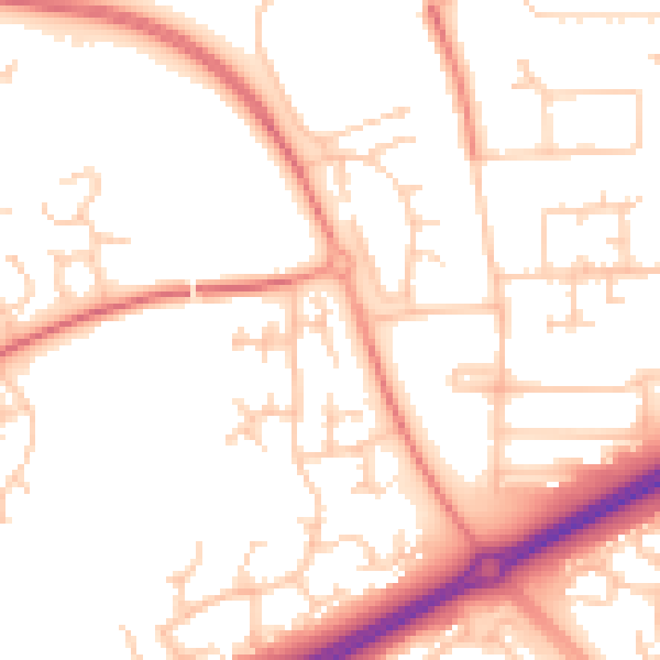
Daytime· 07:00 – 23:00
52.1dB

Night-time· 23:00 – 07:00
41.1dB