5 Raglan Walk, Manchester, M15 6FL
About 5 Raglan Walk
5 Raglan Walk is an end-of-terrace house in Manchester (M15 6FL). It has a recorded floor area of 92 m² (around 990 sq ft), construction records dating it to 1967-1975 and council tax band A. The latest certificate (April 2022) shows a C (score 69), just inside the C band. The recommended improvements would push it to B (score 84).
At 92 m² it's 20.7% smaller than the typical home in the postcode (116 m² median across 4 EPCs). One planning record on file: an extension refused in 2023.
Everything you need to know about 5 Raglan Walk
The true value, the hidden risks and the full sale history, in one report.
30-day money-back guarantee

The data behind every report


Energy performance
EPC Rating
Planning history
A a part-single-part-two-storey side extension application was refused at 5 Raglan Walk in 2023.
- Jun 2023ExtensionFullIn report
Extension: Part single, part two storey · Side of property
Erection of a part single/part two storey side extension to form additional living accommodation.
- Agent
- RA Design & Project Management Ltd
- Documents
- 4 docs on file
- Reference
- 136712/FH/2023
We flagged 1 thing worth checking at 5 Raglan Walk
Independent checks surfaced things a buyer would want to understand before offering. The report explains each one in full, with the underlying data and what to ask.
- A planning decision worth checking
30-day money-back guarantee
Sales history & valuation
5 Raglan Walk has no Land Registry sales on file, suggesting it has stayed in the same hands since registration began.
£187,000
Modelled from EPC, postcode comparables.
No sales recorded with HM Land Registry
That can mean the property has never traded since the registry began publishing in 1995, was a new build that hasn't been registered yet, or is held in the same hands long-term.
Versus other Raglan Walk homes
On floor area, 5 Raglan Walk runs well behind the street norm.
EPC Rating
69 (C)
Street avg 71 (C)
Floor Area
92 m²
Street avg 113 m²
CO₂ Emissions
3.2 t/year
Street avg 3.2 t/year
Habitable Rooms
5 rooms
Street avg 5 rooms
Everything you need to know about 5 Raglan Walk
The true value, the hidden risks and the full sale history, in one report.
30-day money-back guarantee
The data behind every report
Similar properties nearby
The neighbourhood at a glance
Crime
1/mo
Steady year-on-year across the wider district.
Nearest stop
0.2 km
Trinity High School — bus stop.
Closest school
0.3 km
Trinity CofE High School. 46 schools nearby.
Go deeper on the local area
The full report breaks down crime, transport links, schools and air quality in depth.
Road noise across the postcode
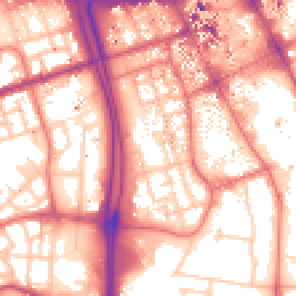
Daytime· 07:00 – 23:00
58.3dB
Night-time· 23:00 – 07:00
48.5dB