14 Bowles Way, Dunstable, LU6 3LX
About 14 Bowles Way
14 Bowles Way is a three-bedroom mid-terrace house in Dunstable (LU6 3LX). It has a recorded floor area of 113 m² (around 1216 sq ft), construction records dating it to 1967-1975 and council tax band C. The latest certificate (August 2021) shows a C (score 72). The recommended improvements would push it to B (score 82).
Across 1999–2021, sale prices on this property compounded at 5.9% per year. Today's modelled estimate of £319,000 is 16.4% above the 2021 sale price. On a £-per-square-foot basis, the last sale (£225/sq ft) was about 22.7% above the typical sold price in the postcode. Last sale on file: £274,000 in December 2021. That sale was during the post-pandemic price surge, when transactions cleared materially above pre-2020 trend.
What this property has
Inside
- Bedrooms3
- Bathrooms1
- Dining roomYes
- EnsuiteYes
- StudyYes
Outside
- Private gardenYes
- GarageSingle
Building
- Central heatingYes
Everything you need to know about 14 Bowles Way
The true value, the hidden risks and the full sale history, in one report.
30-day money-back guarantee

The data behind every report


Energy performance
EPC Rating
Planning history
14 Bowles Way has no planning applications on record.
Notable planning nearby
7applications of note in the surrounding area
We flagged 2 things worth checking at 14 Bowles Way
Independent checks surfaced things a buyer would want to understand before offering. The report explains each one in full, with the underlying data and what to ask.
- Signs of HMO activity in the area
- Larger development activity nearby
30-day money-back guarantee
Sales history & valuation
Sale price has grown by over 3x since 1999.
£319,000
Modelled from EPC, postcode comparables and a sale-price growth of 5.9% per year over 23 years.
£274,000
Growth on file: 5.9% per year over 23 years.
Sales timeline
8 December 2021Most recent
£274,000
+270.3%over 22 years19 February 1999
£74,000
Median price across the last 5 sales in LU6 3LX: £315,000 (2024–2022).
Versus other Bowles Way homes
On price per m², 14 Bowles Way runs well behind the street norm.
Price per m²
£2,425
Street avg £2,529
Floor Area
113 m²
Street avg 114 m²
Habitable Rooms
5 rooms
Street avg 6 rooms
CO₂ Emissions
3.7 t/year
Street avg 4.5 t/year
Everything you need to know about 14 Bowles Way
The true value, the hidden risks and the full sale history, in one report.
30-day money-back guarantee
The data behind every report
Similar properties nearby
1 Burges Close
LU6 3EU
1 Buttercup Close
LU6 3LA
1 Beech Road
LU6 3LY
1 Canesworde Road
LU6 3JJ
1 Buttermere Avenue
LU6 3PD
1 Bowland Crescent
LU6 3QD
1 Appleby Gardens
LU6 3DB
1 Crosby Close
LU6 3BZ
The neighbourhood at a glance
Daytime road noise here sits well below conversation level — a quiet pocket of the postcode.
Crime
3/mo
Steady year-on-year across the wider district.
Nearest stop
0.1 km
Churchill Road — bus stop.
Closest school
0.7 km
St Mary's Catholic Primary School. 18 schools nearby.
Go deeper on the local area
The full report breaks down crime, transport links, schools and air quality in depth.
Road noise across the postcode
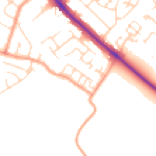
Daytime· 07:00 – 23:00
48.8dB

Night-time· 23:00 – 07:00
39.8dB