7 Fernhill Close, Bootle, L20 9JR
About 7 Fernhill Close
7 Fernhill Close is a mid-terrace house in Bootle (L20 9JR). It has a recorded floor area of 86 m² (around 926 sq ft), construction records dating it to 1950-1966 and council tax band A. The latest certificate (March 2016) shows a C (score 72). The recommended improvements would push it to B (score 83). The latest certificate is from March 2016, so improvements made since then won't be reflected.
Across 2016–2021, sale prices on this property compounded at 14.6% per year. Today's modelled estimate of £135,000 is 35% above the 2021 sale price. Last sale on file: £100,000 in May 2021. That sale was during the post-pandemic price surge, when transactions cleared materially above pre-2020 trend.
Everything you need to know about 7 Fernhill Close
The true value, the hidden risks and the full sale history, in one report.
30-day money-back guarantee

The data behind every report


Energy performance
EPC Expired
This certificate is over 10 years old and is no longer valid.Expired 15 Mar 2026
EPC Rating
Planning history
7 Fernhill Close has no planning applications on record.
Notable planning nearby
7applications of note in the surrounding area
We flagged 1 thing worth checking at 7 Fernhill Close
Independent checks surfaced things a buyer would want to understand before offering. The report explains each one in full, with the underlying data and what to ask.
- Signs of HMO activity in the area
30-day money-back guarantee
Sales history & valuation
7 Fernhill Close has more than doubled in price since the earliest registered sale in 2016.
£135,000
Modelled from EPC, postcode comparables and a sale-price growth of 14.6% per year over 5 years.
£100,000
Growth on file: 14.6% per year over 5 years.
Sales timeline
5 May 2021Most recent
£100,000
+100.0%over 5 years30 March 2016
£50,000
Median price across the last 5 sales in L20 9JR: £105,000 (2025–2018).
Versus other Fernhill Close homes
Price per m²
£1,163
Street avg £1,170
Floor Area
86 m²
Street avg 89 m²
Habitable Rooms
5 rooms
Street avg 5 rooms
CO₂ Emissions
2.8 t/year
Street avg 3.2 t/year
Everything you need to know about 7 Fernhill Close
The true value, the hidden risks and the full sale history, in one report.
30-day money-back guarantee
The data behind every report
Similar properties nearby
The neighbourhood at a glance
Reported crime in the wider district is trending notably upward year-on-year.
Crime
7/mo
Rising year-on-year across the wider district.
Nearest stop
0.1 km
Southport Road — bus stop.
Closest school
0.2 km
Bedford Primary School. 41 schools nearby.
Go deeper on the local area
The full report breaks down crime, transport links, schools and air quality in depth.
Road noise across the postcode
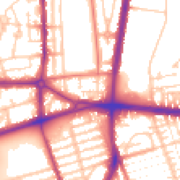
Daytime· 07:00 – 23:00
56.0dB

Night-time· 23:00 – 07:00
46.9dB