Flat 1, 38 Hertford Road, Bootle, L20 7DB
About Flat 1
Flat 1 is a two-bedroom detached house in Bootle (L20 7DB). It has a recorded floor area of 80 m² (around 861 sq ft), construction records dating it to 2012 onwards and council tax band A. At 80 m² this is the largest unit on EPC record across the building (44–80 m²). The latest certificate (March 2023) shows a C (score 80), near the top of the C band. The rating has held steady at C across 2 certificates since December 2012. Between certificates, wall efficiency went from Good to Very Good and lighting went from Very Poor to Very Good; while window efficiency dropped from Good to Average.
At 80 m² it's 24% larger than the typical home in the postcode (65 m² median across 4 EPCs).
What this property has
Inside
- Bedrooms2
- Bathrooms1
Everything you need to know about Flat 1
The true value, the hidden risks and the full sale history, in one report.
30-day money-back guarantee

The data behind every report


Energy performance
EPC Rating
Property Improvements
Changes detected from historical EPC data
Wall insulation improved
More low energy lighting installed
Planning history
Flat 1 has no planning applications on record.
Notable planning nearby
3applications of note in the surrounding area
Sales history & valuation
Flat 1 has no Land Registry sales on file, suggesting it has stayed in the same hands since registration began.
£118,000
Modelled from EPC, postcode comparables.
No sales recorded with HM Land Registry
That can mean the property has never traded since the registry began publishing in 1995, was a new build that hasn't been registered yet, or is held in the same hands long-term.
Versus other Hertford Road homes
On floor area, Flat 1 stands well clear of the street.
EPC Rating
80 (C)
Street avg 78 (C)
Floor Area
80 m²
Street avg 62 m²
CO₂ Emissions
1.7 t/year
Street avg 1.5 t/year
Habitable Rooms
2 rooms
Street avg 3 rooms
Everything you need to know about Flat 1
The true value, the hidden risks and the full sale history, in one report.
30-day money-back guarantee
The data behind every report
Similar properties nearby
Flat 1, 37 Keble Road
L20 7DF
Flat 1, 31 Oriel Road
L20 7AA
Flat 1, 39 Pembroke Road
L20 7BB
Flat 1, 11 Oriel Road
L20 7AA
Flat 1, 17 Trinity Road
L20 7BD
Flat 1, 4 Pembroke Road
L20 7AZ
Flat 1, 37 Oriel Road
L20 7AA
Flat 1, 39 Oriel Road
L20 7AA
The neighbourhood at a glance
Rail-style transport is unusually close for this postcode.
Crime
7/mo
Rising year-on-year across the wider district.
Nearest stop
0.2 km
Marble Close — bus stop.
Closest school
0.2 km
Hugh Baird College. 34 schools nearby.
Go deeper on the local area
The full report breaks down crime, transport links, schools and air quality in depth.
Road noise across the postcode
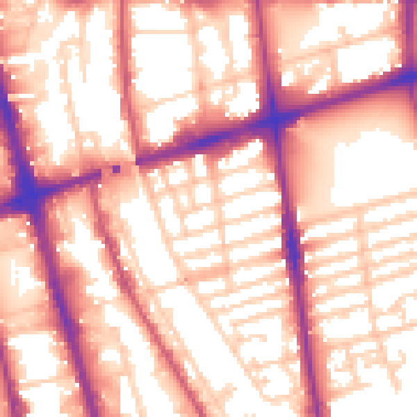
Daytime· 07:00 – 23:00
57.5dB

Night-time· 23:00 – 07:00
49.3dB