14 Assheton Road, Beaconsfield, HP9 2NP
2 planning records
About 14 Assheton Road
A plain-English summary derived from public records, EPC certificates, sold prices and local data.
14 Assheton Road is a detached house in Beaconsfield (HP9 2NP). It has a recorded floor area of 260 m² (around 2799 sq ft) and construction records dating it to 1900-1929. The latest certificate (January 2025) shows a C (score 69), just inside the C band.
Sale prices here have outpaced England HPI: 7.7% per year against 0% for the wider region. On a £-per-square-foot basis, the last sale (£804/sq ft) was about 87.9% above the typical sold price in the postcode. A recent sale: £2,250,000 in May 2025. 2 planning records sit against the property, 0 approved, 1 refused.
Energy performance
Every EPC certificate filed against this property — current rating, recorded improvements, and where there's headroom to reach a higher band.
14 Assheton Road's carbon output runs well above what efficient homes in the postcode produce.
EPC Rating
A
B
C
C69
D
E
F
G
Main Heating
Gas
Main Fuel
Gas
Hot Water
Good
Windows
Good
CO2 Emissions
8.4 t/year
Occupancy
Owner Occupied
Planning history
Applications and permits filed against 14 Assheton Road, Beaconsfield, HP9 2NP, sourced from the PlanIt planning register.
- Feb 2009ExtensionFullGranted
Extension: Side and rear of property
First floor side/rear and single storey rear extensions and roof extension incorporating front and rear dormers.
Sales history & valuation
Recorded transactions, our model's current estimate, and a quick read on what neighbouring properties have sold for.
Price for 14 Assheton Road has grown more than fourfold since the 1995 starting point.
Current estimate
See how we calculated this£2,205,000
Modelled from EPC, postcode comparables and a sale-price growth of 7.7% per year over 29 years.
Last sold (2025)
£2,250,000
Growth on file: 7.7% per year over 29 years.
Sales timeline
Launch offer · 33% off
The complete analysis of 14 Assheton Road, Beaconsfield, HP9 2NP
Everything we know about this property, compiled into one in-depth, downloadable report.
Detailed analysis
A written breakdown of everything that matters
Versus other Assheton Road homes
Four headline reads against 17 similar houses on this street, drawn from the latest EPC and Land Registry data.
Price per m² for 14 Assheton Road runs comfortably ahead of the street norm.
Price per m²
£8,654
Street avg £5,281
Floor Area
260 m²
Street avg 332 m²
Habitable Rooms
9 rooms
Similar properties nearby
A handful of close matches in the same postcode area, ranked by likeness on bedrooms, type and floor area.
The neighbourhood at a glance
A condensed read of the local area. Each tile links through to the full breakdown on the Beaconsfield district page.
Rail-style transport is unusually close for this postcode.
Crime
2/mo
Steady year-on-year across the wider district.
Nearest stop
0.2 km
Wilton Road — bus stop.
Road noise across the postcode
Modelled day and night-time noise levels around HP9 2NP from Defra's strategic mapping. The pin marks this postcode's centroid.
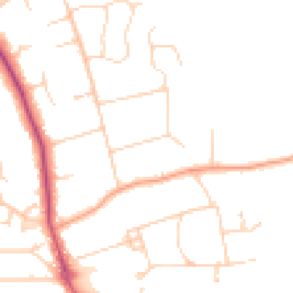
Daytime· 07:00 – 23:00
47.2dB

Everything within walking distance
Schools, transport stops and scenic spots near this property — 36 points of interest in total.
Common questions
The questions buyers, sellers and homeowners most often ask about 14 Assheton Road, Beaconsfield, HP9 2NP. Each answer is also embedded as structured data for search engines.
