Are you a property professional?Get qualified leads from motivated homeowners.
Get started5 Farm Hill Road, Waltham Abbey, EN9 1NE
About 5 Farm Hill Road
A plain-English summary derived from public records, EPC certificates, sold prices and local data.
5 Farm Hill Road is a three-bedroom semi-detached house in Waltham Abbey (EN9 1NE). It has a recorded floor area of 120 m² (around 1292 sq ft), construction records dating it to 1900-1929 and council tax band E. The latest certificate (October 2020) shows a D (score 59), a step below the typical UK home. The recommended improvements would lift it to B (score 84), a 2-band jump.
At 120 m² the property is well over the postcode median (82 m² across 18 EPCs), placing it in the larger end of the local stock. Today's modelled estimate of £520,000 is 18.2% above the 2021 sale price. On a £-per-square-foot basis, the last sale (£341/sq ft) was about 64.4% above the typical sold price in the postcode. Sold June 2021 for £440,000. That sale was during the post-pandemic price surge, when transactions cleared materially above pre-2020 trend.
What this property has
Pulled from EPC certificates, claim submissions and our property model. Empty categories are hidden — we only show what's known.
Inside
- Bedrooms3
- Bathrooms1
- Dining roomYes
- CloakroomYes
Energy performance
Every EPC certificate filed against this property — current rating, recorded improvements, and where there's headroom to reach a higher band.
Recommended upgrades on file would lift this property by multiple EPC bands.
EPC Rating
A
B
C
D
D59
E
F
G
Main Heating
Gas
Main Fuel
Gas
Hot Water
Good
Windows
Average
CO2 Emissions
5.6 t/year
Occupancy
Owner Occupied
Sales history & valuation
Recorded transactions, our model's current estimate, and a quick read on what neighbouring properties have sold for.
The latest sale landed in the post-pandemic price surge — useful context when reading the figure.
Current estimate
See how we calculated this£520,000
Modelled from EPC, postcode comparables.
Last sold (2021)
£440,000
Recorded with HM Land Registry.
Sales timeline
Versus other Farm Hill Road homes
Four headline reads against 11 similar houses on this street, drawn from the latest EPC and Land Registry data.
Floor Area for 5 Farm Hill Road runs comfortably ahead of the street norm.
Price per m²
£3,667
Street avg £3,252
Floor Area
120 m²
Street avg 102 m²
Habitable Rooms
5 rooms
Similar properties nearby
A handful of close matches in the same postcode area, ranked by likeness on bedrooms, type and floor area.
The neighbourhood at a glance
A condensed read of the local area. Each tile links through to the full breakdown on the Waltham Abbey district page.
Reported crime in the wider district is trending notably upward year-on-year.
Crime
4/mo
Rising year-on-year across the wider district.
Nearest stop
0.1 km
Road noise across the postcode
Modelled day and night-time noise levels around EN9 1NE from Defra's strategic mapping. The pin marks this postcode's centroid.
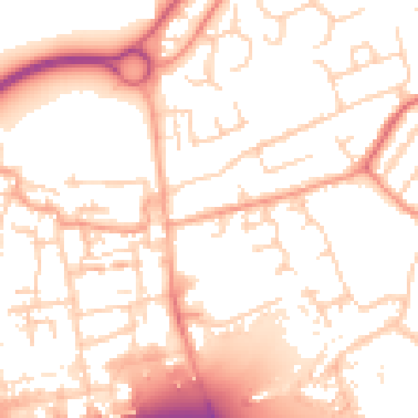
Daytime· 07:00 – 23:00
53.7dB

Everything within walking distance
Schools, transport stops and scenic spots near this property — 45 points of interest in total.
Beautiful places to visit nearby
Curated scenic spots within reach of this postcode, served by Beautifulplaces.ai. Photography and tagging come from their open dataset.
Common questions
The questions buyers, sellers and homeowners most often ask about 5 Farm Hill Road, Waltham Abbey, EN9 1NE. Each answer is also embedded as structured data for search engines.