23 Stonehorse Road, Enfield, EN3 4DA
About 23 Stonehorse Road
23 Stonehorse Road is a semi-detached house in Enfield (EN3 4DA). It has a recorded floor area of 37 m² (around 398 sq ft), construction records dating it to 1983-1990 and council tax band B. At 37 m² this is the 15th smallest of 27 units on EPC record in the building, where floor areas span 29–66 m². The building's EPC ratings span D to C, with this unit at the bottom. The latest certificate (October 2019) shows a D (score 67), on the cusp of jumping into the C band. The recommended improvements would push it to C (score 76).
It lags the bulk of the postcode on energy efficiency (less efficient than 81% of similar EPCs). Today's modelled estimate of £207,000 is 25.5% above the 2020 sale price. On a £-per-square-foot basis, the last sale (£414/sq ft) was about 63.4% above the typical sold price in the postcode. Most recent transfer: February 2020 at £165,000.
Everything you need to know about 23 Stonehorse Road
The true value, the hidden risks and the full sale history, in one report.
30-day money-back guarantee

The data behind every report


Energy performance
EPC Rating
Planning history
23 Stonehorse Road has no planning applications on record.
Notable planning nearby
39applications of note in the surrounding area
We flagged 1 thing worth checking at 23 Stonehorse Road
Independent checks surfaced things a buyer would want to understand before offering. The report explains each one in full, with the underlying data and what to ask.
- Signs of HMO activity in the area
30-day money-back guarantee
Sales history & valuation
The latest sale landed in the post-pandemic price surge — useful context when reading the figure.
£207,000
Modelled from EPC, postcode comparables.
£165,000
Recorded with HM Land Registry.
Sales timeline
28 February 2020Most recent
£165,000
Median price across the last 5 sales in EN3 4DA: £207,000 (2024–2021).
Nearby sales in EN3 4DA
Versus other Stonehorse Road homes
23 Stonehorse Road is notably below the street on epc rating.
Price per m²
£4,459
Street avg £3,592
Floor Area
37 m²
Street avg 39 m²
Habitable Rooms
3 rooms
Street avg 2 rooms
CO₂ Emissions
1.8 t/year
Street avg 1.5 t/year
Everything you need to know about 23 Stonehorse Road
The true value, the hidden risks and the full sale history, in one report.
30-day money-back guarantee
The data behind every report
Similar properties nearby
The neighbourhood at a glance
Rail-style transport is unusually close for this postcode.
Crime
8/mo
Rising year-on-year across the wider district.
Nearest stop
0.1 km
Ponders End Park — bus stop.
Closest school
0.2 km
St Matthew's CofE Primary School. 44 schools nearby.
Go deeper on the local area
The full report breaks down crime, transport links, schools and air quality in depth.
Road noise across the postcode
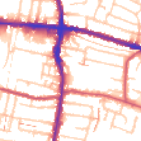
Daytime· 07:00 – 23:00
54.5dB

Night-time· 23:00 – 07:00
43.7dB