17 Cleeve Workshops, Boundary Street, Hackney, London, E2 7JD
We're still gathering data on this property. Claim it to add details and complete this page.
About 17 Cleeve Workshops
A plain-English summary derived from public records, EPC certificates, sold prices and local data.
17 Cleeve Workshops is a property in Hackney, London, London (E2 7JD).
Energy performance
Every EPC certificate filed against this property — current rating, recorded improvements, and where there's headroom to reach a higher band.
No EPC on record
This property doesn't have an Energy Performance Certificate yet. An EPC is required to sell or let — and unlocks our automated valuation.
Planning history
Applications and permits filed against 17 Cleeve Workshops, Boundary Street, Hackney, London, E2 7JD, sourced from the PlanIt planning register.
No planning applications are recorded against 17 Cleeve Workshops, Boundary Street, Hackney, London, E2 7JD. The full report also covers planning activity across the surrounding area.
Similar properties nearby
A handful of close matches in the same postcode area, ranked by likeness on bedrooms, type and floor area.
£345k
1 11, Shacklewell Street, Tower Hamlets
E2 7EG
£553k
1 1a, Flat 10, Old Nichol Street, Tower Hamlets
E2 7HR
Flat
1 Arnold Circus, Tower Hamlets
E2 7ES
£240k
1 Baroness Road, Tower Hamlets
E2 7PW
1 Blackbird Yard, Tower Hamlets
E2 7RP
1 Boundary Street, Tower Hamlets
E2 7JE
2 bed2 bath
£981k
1 Chambord Street, Tower Hamlets
E2 7NJ
4 bed2 bath
£484k
1 Delta Point, Delta Street, Tower Hamlets
E2 7BF
The neighbourhood at a glance
A condensed read of the local area. Each tile links through to the full breakdown on the London district page.
Rail-style transport is unusually close for this postcode.
Crime
11/mo
Falling year-on-year across the wider district.
Nearest stop
0.0 km
Calvert Avenue / Shoreditch — bus stop.
Closest school
0.1 km
Virginia Primary School. 109 schools nearby.
Road noise across the postcode
Modelled day and night-time noise levels around E2 7JD from Defra's strategic mapping. The pin marks this postcode's centroid.
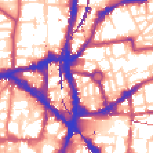
Daytime· 07:00 – 23:00
59.9dB
Night-time· 23:00 – 07:00
50.5dB
55 dB
60 dB
65 dB
70 dB
75 dB
80 dB
Defra Road Noise Strategic Mapping, Round 4Common questions
The questions buyers, sellers and homeowners most often ask about 17 Cleeve Workshops, Boundary Street, Hackney, London, E2 7JD. Each answer is also embedded as structured data for search engines.