173 Fletchamstead Highway, Coventry, CV4 7BA
About 173 Fletchamstead Highway
173 Fletchamstead Highway is a mid-terrace house in Coventry (CV4 7BA). It has a recorded floor area of 133 m² (around 1432 sq ft), construction records dating it to 1950-1966 and council tax band B. The latest certificate (November 2022) shows a C (score 74). When first surveyed in May 2018 the rating was D, the property has climbed 1 band since. Between certificates, window efficiency went from Average to Good, hot-water efficiency went from Poor to Good and lighting went from Poor to Very Good. The recommended improvements would push it to B (score 84).
At 133 m² the property is well over the postcode median (86 m² across 23 EPCs), placing it in the larger end of the local stock. 2 planning records sit against the property, 2 approved, 0 refused. Past consents include an extension and HMO conversion, meaningful when judging how the property has evolved. Across 2018–2021, sale prices on this property compounded at 19.1% per year. On a £-per-square-foot basis, the last sale (£279/sq ft) was about 118% above the typical sold price in the postcode. Last sale on file: £400,000 in March 2021. That sale was during the post-pandemic price surge, when transactions cleared materially above pre-2020 trend.
Know exactly what you're buying at 173 Fletchamstead Highway
Before you offer, see what the listing won't tell you, the true value, the red flags and the full history.
Already flagged here
Valuation
against the asking price
Risks
planning & flood
Sold prices
similar homes nearby
Trends
the local market
Energy performance
EPC Rating
Property Improvements
Changes detected from historical EPC data
Heating controls upgraded for better temperature management
Hot water system upgraded
Window efficiency improved
Roof insulation improved
More low energy lighting installed
Planning history
173 Fletchamstead Highway has an approved rear extension on the planning record.
- Sept 2023HMOAmendmentIn report
Application for Lawful Development Certificate for existing use as a small HMO with 6 occupants
Retrospective- Reference
- PL/2023/0002003/LDCE
- Nov 2018ExtensionOutlineIn report
Extension: Rear of property
Application under Prior Approval for rear extension. The extension will be 6.00 metres away from the original rear wall of the building with a height of 3.150 metres at the highest point and 2.900 metres to the eaves.
- Documents
- 8 docs on file
- Reference
- PA/2018/3002
We flagged 1 thing worth checking at 173 Fletchamstead Highway
Independent checks surfaced things a buyer would want to understand before offering. The report explains each one in full, with the underlying data and what to ask.
- Signs of HMO activity in the area
30-day money-back guarantee
Sales history & valuation
The latest sale landed in the post-pandemic price surge — useful context when reading the figure.
£383,000
Modelled from EPC, postcode comparables and a sale-price growth of 19.1% per year over 2 years.
£400,000
Growth on file: 19.1% per year over 2 years.
Sales timeline
28 March 2021Most recent
£400,000
+53.8%over 2 years11 October 2018
£260,000
Median price across the last 5 sales in CV4 7BA: £245,000 (2020–2014).
Nearby sales in CV4 7BA
157 Fletchamstead Highway, Coventry, CV4 7BA
Sold May 2020
£245,000153 Fletchamstead Highway, Coventry, CV4 7BA
Sold Sept 2017
£3,174,837155 Fletchamstead Highway, Coventry, CV4 7BA
Sold Mar 2016
£200,000165 Fletchamstead Highway, Coventry, CV4 7BA
Sold Nov 2015
£251,000161 Fletchamstead Highway, Coventry, CV4 7BA
Sold Sept 2014
£215,000
Everything we know about 173 Fletchamstead Highway, in one report
What it's really worth, what could be wrong, and the planning, sales and area data in full.
What we flagged
- Signs of HMO activity in the area

Versus other Fletchamstead Highway homes
On years held, 173 Fletchamstead Highway runs well behind the street norm.
Price per m²
£3,008
Street avg £3,680
Floor Area
133 m²
Street avg 88 m²
Habitable Rooms
7 rooms
Street avg 5 rooms
CO₂ Emissions
3.9 t/year
Street avg 3.1 t/year
Similar properties nearby
The neighbourhood at a glance
Rail-style transport is unusually close for this postcode.
Crime
7/mo
Steady year-on-year across the wider district.
Nearest stop
0.9 km
Canley Rail Station — railway station.
Closest school
1.0 km
Cannon Park Primary School. 28 schools nearby.
Go deeper on the local area
The full report breaks down crime, transport links, schools and air quality in depth.
Road noise across the postcode
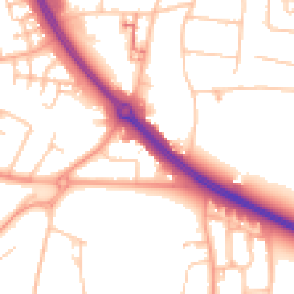
Daytime· 07:00 – 23:00
53.2dB

Night-time· 23:00 – 07:00
43.8dB