2 Chestnut Close, Mile End, Colchester, CO4 5JH
About 2 Chestnut Close
2 Chestnut Close is a four-bedroom semi-detached house in Mile End, Colchester, Colchester (CO4 5JH). It has a recorded floor area of 122 m² (around 1313 sq ft), construction records dating it to 2003-2006 and council tax band E. The latest certificate (November 2016) shows a C (score 70).
Across 2006–2021, sale prices on this property compounded at 2.1% per year. On a £-per-square-foot basis, the last sale (£298/sq ft) was about 19.2% above the typical sold price in the postcode. Last sale on file: £391,034 in June 2021. That sale was during the post-pandemic price surge, when transactions cleared materially above pre-2020 trend.
Know exactly what you're buying at 2 Chestnut Close
Before you offer, see what the listing won't tell you, the true value, the red flags and the full history.
Already flagged here
Valuation
against the asking price
Risks
planning & flood
Sold prices
similar homes nearby
Trends
the local market
What this property has
Inside
- Bedrooms4
- Bathrooms2
Energy performance
EPC Rating
Planning history
2 Chestnut Close has no planning applications on record.
Notable planning nearby
14applications of note in the surrounding area
We flagged 2 things worth checking at 2 Chestnut Close
Independent checks surfaced things a buyer would want to understand before offering. The report explains each one in full, with the underlying data and what to ask.
- Signs of HMO activity in the area
- Larger development activity nearby
30-day money-back guarantee
Sales history & valuation
The latest sale landed in the post-pandemic price surge — useful context when reading the figure.
£427,000
Modelled from EPC, postcode comparables and a sale-price growth of 2.1% per year over 15 years.
£391,034
Growth on file: 2.1% per year over 15 years.
Sales timeline
29 June 2021Most recent
£391,034
+36.0%over 14 years19 October 2006
£287,500
Median price across the last 5 sales in CO4 5JH: £285,500 (2019–2006).
Everything we know about 2 Chestnut Close, in one report
What it's really worth, what could be wrong, and the planning, sales and area data in full.
What we flagged
- Signs of HMO activity in the area
- Larger development activity nearby

Similar properties nearby
The neighbourhood at a glance
Crime
5/mo
Steady year-on-year across the wider district.
Nearest stop
0.1 km
Whitebeam Close — bus stop.
Closest school
0.6 km
Myland Community Primary School. 15 schools nearby.
Go deeper on the local area
The full report breaks down crime, transport links, schools and air quality in depth.
Road noise across the postcode
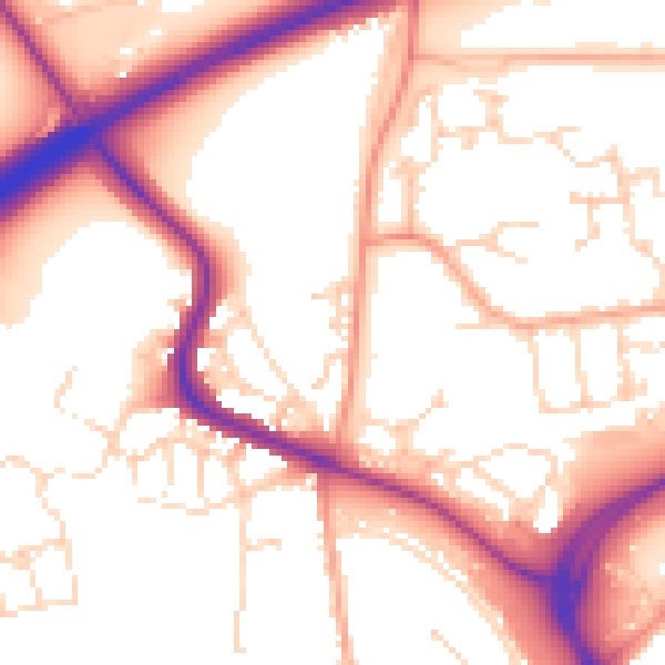
Daytime· 07:00 – 23:00
54.9dB

Night-time· 23:00 – 07:00
45.7dB