Are you a property professional?Get qualified leads from motivated homeowners.
Get started2 Broxted Mews, Brentwood, CM13 1YZ
2 planning records
About 2 Broxted Mews
A plain-English summary derived from public records, EPC certificates, sold prices and local data.
2 Broxted Mews is a four-bedroom detached house in Brentwood (CM13 1YZ). It has a recorded floor area of 145 m² (around 1561 sq ft), construction records dating it to 1991-1995 and council tax band G. The latest certificate (April 2016) shows a D (score 67), on the cusp of jumping into the C band. The recommended improvements would push it to C (score 79). The latest certificate is from April 2016, so improvements made since then won't be reflected.
Sale prices here have outpaced Brentwood HPI: 3.8% per year against 0% for the wider region. Today's modelled estimate of £1,162,000 is 19.2% above the 2022 sale price. On a £-per-square-foot basis, the last sale (£625/sq ft) was about 129.8% above the typical sold price in the postcode. 2 planning records sit against the property, 1 approved, 1 refused. Past consents include an extension, meaningful when judging how the property has evolved. Last sale on file: £975,000 in June 2022. That sale was during the post-pandemic price surge, when transactions cleared materially above pre-2020 trend.
What this property has
Pulled from EPC certificates, claim submissions and our property model. Empty categories are hidden — we only show what's known.
Inside
- Bedrooms4
- Bathrooms3
- Open-plan layoutYes
- Dining roomYes
Energy performance
Every EPC certificate filed against this property — current rating, recorded improvements, and where there's headroom to reach a higher band.
EPC Expired
This certificate is over 10 years old and is no longer valid.Expired 25 Apr 2026
EPC Rating
A
B
C
D
D67
E
F
G
Main Heating
Gas
Main Fuel
Gas
Hot Water
Good
Windows
Average
CO2 Emissions
5.2 t/year
Occupancy
Owner Occupied
Planning history
Applications and permits filed against 2 Broxted Mews, Brentwood, CM13 1YZ, sourced from the PlanIt planning register.
2 Broxted Mews has 2 separate extension applications on the council record.
- Oct 2017ExtensionOutlineGranted
Extension: Single storey · Rear of property
Application for a lawful development certificate for a proposed use or development for single storey rear extension with roof lantern
Sales history & valuation
Recorded transactions, our model's current estimate, and a quick read on what neighbouring properties have sold for.
The latest sale landed in the post-pandemic price surge — useful context when reading the figure.
Current estimate
See how we calculated this£1,162,000
Modelled from EPC, postcode comparables and a sale-price growth of 3.8% per year over 6 years.
Last sold (2022)
£975,000
Growth on file: 3.8% per year over 6 years.
Sales timeline
Similar properties nearby
A handful of close matches in the same postcode area, ranked by likeness on bedrooms, type and floor area.
The neighbourhood at a glance
A condensed read of the local area. Each tile links through to the full breakdown on the Brentwood district page.
Rail-style transport is unusually close for this postcode.
Crime
4/mo
Steady year-on-year across the wider district.
Nearest stop
0.2 km
Hanging Hill Lane — bus stop.
Road noise across the postcode
Modelled day and night-time noise levels around CM13 1YZ from Defra's strategic mapping. The pin marks this postcode's centroid.
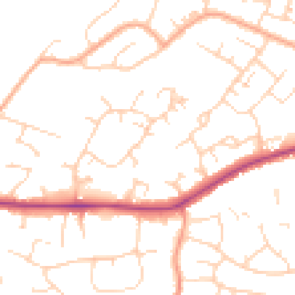
Daytime· 07:00 – 23:00
49.8dB

Everything within walking distance
Schools, transport stops and scenic spots near this property — 43 points of interest in total.
Beautiful places to visit nearby
Curated scenic spots within reach of this postcode, served by Beautifulplaces.ai. Photography and tagging come from their open dataset.
Common questions
The questions buyers, sellers and homeowners most often ask about 2 Broxted Mews, Brentwood, CM13 1YZ. Each answer is also embedded as structured data for search engines.