Are you a property professional?Get qualified leads from motivated homeowners.
Get startedThe Junction, Flat 2, Alexander Lane, Hutton, Brentwood, CM13 1AY
About The Junction
A plain-English summary derived from public records, EPC certificates, sold prices and local data.
The Junction is a two-bedroom mid-terrace house in Hutton, Brentwood, Brentwood (CM13 1AY). It has a recorded floor area of 70 m² (around 753 sq ft), construction records dating it to 1983-1990 and council tax band E. The property has underfloor heating on record, all of which lower running costs and tend to lift resale appeal. Other recorded features include a balcony. At 70 m² this is the 6th smallest of 12 units on EPC record in The Junction, where floor areas span 67–78 m². The building's EPC ratings span D to B, with this unit at the bottom. The latest certificate (August 2019) shows a D (score 68), on the cusp of jumping into the C band. Earlier certificates rated it C (October 2008); the latest reading is one band lower. Between certificates, window efficiency went from Average to Good and lighting went from Poor to Very Good; while main heating dropped from Poor to Very Poor. Main heating runs on electricity.
It hasn't traded since June 2007, a hold of 19 years that's notably long for the area. That sale landed at the peak of the pre-credit-crunch market, which is a useful reference point when interpreting the price. On energy efficiency it sits in the bottom 10% of properties in this postcode — significant headroom for improvement. Today's modelled estimate of £392,000 is 30.7% above the 2007 sale price.
What this property has
Pulled from EPC certificates, claim submissions and our property model. Empty categories are hidden — we only show what's known.
Inside
- Bedrooms2
- Bathrooms2
- Open-plan layoutYes
- EnsuiteYes
Energy performance
Every EPC certificate filed against this property — current rating, recorded improvements, and where there's headroom to reach a higher band.
The Junction sits at the bottom of the postcode for energy efficiency — meaningful headroom to improve.
Current Certificate(1 of 2)
Aug 2019
EPC Rating
A
B
C
D
D68
E
F
G
Main Heating
Electric
Main Fuel
Electric
Hot Water
Average
Windows
Good
CO2 Emissions
2.5 t/year
Occupancy
Rented
Sales history & valuation
Recorded transactions, our model's current estimate, and a quick read on what neighbouring properties have sold for.
The latest sale landed at the peak of the pre-credit-crunch market — a high-water reference point.
Current estimate
See how we calculated this£392,000
Modelled from EPC, postcode comparables.
Last sold (2007)
£300,000
Recorded with HM Land Registry.
Sales timeline
Versus other Alexander Lane homes
Four headline reads against 11 similar flats on this street, drawn from the latest EPC and Land Registry data.
On epc rating, The Junction runs well behind the street norm.
Price per m²
£4,286
Street avg £4,550
Floor Area
70 m²
Street avg 72 m²
Habitable Rooms
3 rooms
Street avg 3 rooms
Similar properties nearby
A handful of close matches in the same postcode area, ranked by likeness on bedrooms, type and floor area.
The neighbourhood at a glance
A condensed read of the local area. Each tile links through to the full breakdown on the Brentwood district page.
Rail-style transport is unusually close for this postcode.
Crime
4/mo
Steady year-on-year across the wider district.
Nearest stop
0.3 km
Shenfield Railway Station — bus stop.
Road noise across the postcode
Modelled day and night-time noise levels around CM13 1AY from Defra's strategic mapping. The pin marks this postcode's centroid.
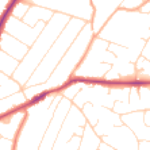
Daytime· 07:00 – 23:00
49.8dB

Everything within walking distance
Schools, transport stops and scenic spots near this property — 45 points of interest in total.
Beautiful places to visit nearby
Curated scenic spots within reach of this postcode, served by Beautifulplaces.ai. Photography and tagging come from their open dataset.
Common questions
The questions buyers, sellers and homeowners most often ask about The Junction, Flat 2, Alexander Lane, Hutton, Brentwood, CM13 1AY. Each answer is also embedded as structured data for search engines.