4 Laurelhurst Avenue, Wirral, CH61 9NY
About 4 Laurelhurst Avenue
4 Laurelhurst Avenue is a semi-detached house in Wirral (CH61 9NY). It has a recorded floor area of 70 m² (around 750 sq ft), construction records dating it to 1930-1949 and council tax band C. The latest certificate (April 2009) shows a D (score 56), a step below the typical UK home. The latest certificate is from April 2009, so improvements made since then won't be reflected.
Untraded for 16 years, with the last transfer in November 2010. Today's modelled estimate of £239,000 sits 83.8% above the 2010 sale of £130,000.
Everything you need to know about 4 Laurelhurst Avenue
The true value, the hidden risks and the full sale history, in one report.
30-day money-back guarantee

The data behind every report


Energy performance
4 Laurelhurst Avenue's EPC is over a decade old — improvements since won't be reflected.
EPC Expired
This certificate is over 10 years old and is no longer valid.Expired 22 Apr 2019
EPC Rating
Planning history
4 Laurelhurst Avenue has no planning applications on record.
The full report still covers planning activity across the surrounding area.
Sales history & valuation
4 Laurelhurst Avenue valuation sits well clear of the typical sold price in this postcode.
£239,000
Modelled from EPC, postcode comparables.
£130,000
Recorded with HM Land Registry.
Sales timeline
19 November 2010Most recent
£130,000
Median price across the last 5 sales in CH61 9NY: £255,000 (2024–2021).
Nearby sales in CH61 9NY
Versus other Laurelhurst Avenue homes
Floor Area for 4 Laurelhurst Avenue lags the street by a wide margin.
Price per m²
£1,865
Street avg £2,294
Floor Area
70 m²
Street avg 86 m²
Habitable Rooms
4 rooms
Street avg 5 rooms
CO₂ Emissions
3.9 t/year
Street avg 4.9 t/year
Everything you need to know about 4 Laurelhurst Avenue
The true value, the hidden risks and the full sale history, in one report.
30-day money-back guarantee
The data behind every report
Similar properties nearby
10 Bentley Road
CH61 9QB
1 Fishers Lane
CH61 9NT
1 Belmont Drive
CH61 9NA
1 Shearman Close
CH61 9PA
1 Kings Drive, Thingwall
CH61 9PX
1 Ryland Park
CH61 9QJ
10 Beech Avenue, Pensby
CH61 9NU
1 Marksway
CH61 9PB
The neighbourhood at a glance
Daytime road noise here sits well below conversation level — a quiet pocket of the postcode.
Crime
2/mo
Steady year-on-year across the wider district.
Nearest stop
0.2 km
Beech Avenue — bus stop.
Closest school
0.4 km
Pensby Primary School. 10 schools nearby.
Go deeper on the local area
The full report breaks down crime, transport links, schools and air quality in depth.
Road noise across the postcode
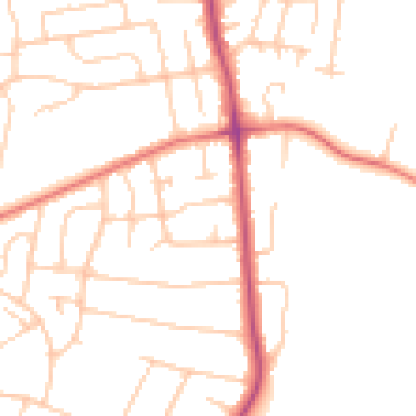
Daytime· 07:00 – 23:00
48.6dB

Night-time· 23:00 – 07:00
38.6dB