1a, Laurelhurst Avenue, Wirral, CH61 9NY
About 1a
1a is a detached house in Wirral (CH61 9NY). It has a recorded floor area of 62 m² (around 667 sq ft), construction records dating it to 1930-1949 and council tax band D. The latest certificate (July 2024) shows a D (score 68), on the cusp of jumping into the C band. When first surveyed in December 2015 the rating was E, the property has climbed 1 band since. Between certificates, wall efficiency went from Very Poor to Good, roof efficiency went from Average to Good and window efficiency went from Average to Good; while hot-water efficiency dropped from Very Good to Good. The recommended improvements would lift it to B (score 86), a 2-band jump.
It hasn't traded since August 2004, a hold of 22 years that's notably long for the area. Today's modelled estimate of £308,000 sits 62.1% above the 2004 sale of £189,950. On a £-per-square-foot basis, the last sale (£285/sq ft) was about 64.3% above the typical sold price in the postcode. At 62 m² it's 22% smaller than the typical home in the postcode (80 m² median across 18 EPCs).
Everything you need to know about 1a
The true value, the hidden risks and the full sale history, in one report.
30-day money-back guarantee

The data behind every report


Energy performance
Recommended upgrades on file would lift this property by multiple EPC bands.
EPC Rating
Property Improvements
Changes detected from historical EPC data
Heating controls upgraded for better temperature management
Hot water efficiency decreased
Windows upgraded to triple glazing
Wall insulation improved
Loft insulation upgraded to recommended levels
More low energy lighting installed
Planning history
1a has no planning applications on record.
The full report still covers planning activity across the surrounding area.
Sales history & valuation
1a valuation sits well clear of the typical sold price in this postcode.
£308,000
Modelled from EPC, postcode comparables.
£189,950
Recorded with HM Land Registry.
Sales timeline
15 August 2004Most recent
£189,950
Median price across the last 5 sales in CH61 9NY: £255,000 (2024–2021).
Nearby sales in CH61 9NY
Versus other Laurelhurst Avenue homes
Floor Area for 1a lags the street by a wide margin.
Price per m²
£3,064
Street avg £2,219
Floor Area
62 m²
Street avg 86 m²
Habitable Rooms
4 rooms
Street avg 5 rooms
CO₂ Emissions
2.4 t/year
Street avg 5.0 t/year
Everything you need to know about 1a
The true value, the hidden risks and the full sale history, in one report.
30-day money-back guarantee
The data behind every report
Similar properties nearby
The neighbourhood at a glance
Daytime road noise here sits well below conversation level — a quiet pocket of the postcode.
Crime
2/mo
Steady year-on-year across the wider district.
Nearest stop
0.2 km
Beech Avenue — bus stop.
Closest school
0.4 km
Pensby Primary School. 10 schools nearby.
Go deeper on the local area
The full report breaks down crime, transport links, schools and air quality in depth.
Road noise across the postcode
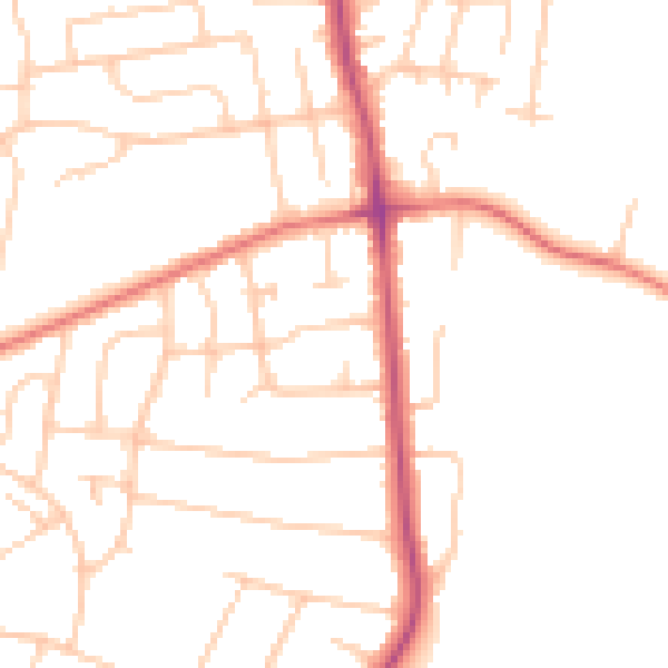
Daytime· 07:00 – 23:00
48.6dB

Night-time· 23:00 – 07:00
38.6dB