33 Cheverton Close, Wirral, CH49 8JN
About 33 Cheverton Close
A plain-English summary derived from public records, EPC certificates, sold prices and local data.
33 Cheverton Close is a three-bedroom mid-terrace house in Wirral (CH49 8JN). It has a recorded floor area of 70 m² (around 753 sq ft), construction records dating it to 1967-1975 and council tax band A. The latest certificate (February 2026) shows a D (score 65), on the cusp of jumping into the C band. The rating has held steady at D across 2 certificates since October 2009. Between certificates, roof efficiency went from Very Poor to Average, hot-water efficiency went from Average to Good and main heating went from Average to Good; while window efficiency dropped from Good to Poor. The recommended improvements would push it to C (score 77). This certificate was lodged in the last six months, so the rating reflects current condition.
Sale prices here have outpaced Wirral HPI: 5.1% per year against 0% for the wider region. Today's modelled estimate of £150,000 sits 50% above the 2022 sale of £100,000. On a £-per-square-foot basis, the last sale (£133/sq ft) was about 154% above the typical sold price in the postcode. Most recent transfer: July 2022 at £100,000. That sale was during the post-pandemic price surge, when transactions cleared materially above pre-2020 trend.
What this property has
Pulled from EPC certificates, claim submissions and our property model. Empty categories are hidden — we only show what's known.
Inside
- Bedrooms3
- Bathrooms1
- Open-plan layoutYes
- CloakroomYes
Energy performance
Every EPC certificate filed against this property — current rating, recorded improvements, and where there's headroom to reach a higher band.
The EPC has just been inspected, so the rating reflects current condition.
Current Certificate(1 of 2)
Feb 2026
EPC Rating
A
B
C
D
D65
E
F
G
Main Heating
Gas
Main Fuel
Gas
Hot Water
Good
Windows
Poor
CO2 Emissions
2.5 t/year
Occupancy
Owner Occupied
Planning history
Applications and permits filed against 33 Cheverton Close, Wirral, CH49 8JN, sourced from the PlanIt planning register.
No planning applications are recorded against 33 Cheverton Close, Wirral, CH49 8JN. The full report also covers planning activity across the surrounding area.
Full planning data for 33 Cheverton Close, Wirral, CH49 8JN
Every application and decision on this property and nearby, in full, in the report.
Sales history & valuation
Recorded transactions, our model's current estimate, and a quick read on what neighbouring properties have sold for.
33 Cheverton Close has more than tripled in price since its earliest registered sale in 1996.
Current estimate
See how we calculated this£150,000
Modelled from EPC, postcode comparables and a sale-price growth of 5.1% per year over 26 years.
Last sold (2022)
£100,000
Growth on file: 5.1% per year over 26 years.
Sales timeline
Launch offer · 33% off
The complete analysis of 33 Cheverton Close, Wirral, CH49 8JN
Everything we know about this property, compiled into one in-depth, downloadable report.
Detailed analysis
A written breakdown of everything that matters
Versus other Cheverton Close homes
Four headline reads against 11 similar houses on this street, drawn from the latest EPC and Land Registry data.
On years held, 33 Cheverton Close runs well behind the street norm.
Price per m²
£1,429
Street avg £1,046
Floor Area
70 m²
Street avg 75 m²
Habitable Rooms
4 rooms
Similar properties nearby
A handful of close matches in the same postcode area, ranked by likeness on bedrooms, type and floor area.
The neighbourhood at a glance
A condensed read of the local area. Each tile links through to the full breakdown on the Wirral district page.
Crime
4/mo
Steady year-on-year across the wider district.
Nearest stop
0.1 km
Selbourne Close — bus stop.
Road noise across the postcode
Modelled day and night-time noise levels around CH49 8JN from Defra's strategic mapping. The pin marks this postcode's centroid.
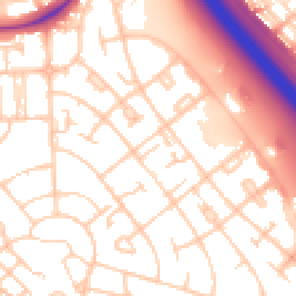
Daytime· 07:00 – 23:00
55.0dB

Everything within walking distance
Schools, transport stops and scenic spots near this property — 59 points of interest in total.
Common questions
The questions buyers, sellers and homeowners most often ask about 33 Cheverton Close, Wirral, CH49 8JN. Each answer is also embedded as structured data for search engines.
