49 Jellicoe Drive, Wirral, CH46 8AH
About 49 Jellicoe Drive
49 Jellicoe Drive is a detached house in Wirral (CH46 8AH). It has a recorded floor area of 48 m² (around 517 sq ft) and construction records dating it to 2022. At 48 m² this is the smallest unit on EPC record across the building (48–124 m²). On EPC score it ranks last in the building (82 versus a best of 85). The latest certificate (December 2022) returns a B (score 82), comfortably above the UK average.
Today's modelled estimate of £189,000 sits 117% above the 2023 sale of £87,100. On a £-per-square-foot basis, the last sale (£169/sq ft) was about 38.3% below the postcode norm. At 48 m² it's 29.4% smaller than the typical home in the postcode (68 m² median across 35 EPCs). Sold January 2023 for £87,100.
Know exactly what you're buying at 49 Jellicoe Drive
Before you offer, see what the listing won't tell you, the true value, the red flags and the full history.
Valuation
against the asking price
Risks
planning & flood
Sold prices
similar homes nearby
Trends
the local market
Energy performance
49 Jellicoe Drive's carbon output is low for the local stock.
EPC Rating
Planning history
49 Jellicoe Drive has no planning applications on record.
The full report still covers planning activity across the surrounding area.
Sales history & valuation
£189,000
Modelled from EPC, postcode comparables.
£87,100
Recorded with HM Land Registry.
Sales timeline
31 January 2023Most recent
£87,100
Median price across the last 5 sales in CH46 8AH: £280,000 (2025–2023).
Nearby sales in CH46 8AH
Everything we know about 49 Jellicoe Drive, in one report
What it's really worth, what could be wrong, and the planning, sales and area data in full.
- Am I paying too much?
- Is something wrong with it?
- Is the agent's story true?
- Will it hold its value?

Versus other Jellicoe Drive homes
On epc rating, 49 Jellicoe Drive runs well behind the street norm.
Price per m²
£1,815
Street avg £2,593
Floor Area
48 m²
Street avg 50 m²
CO₂ Emissions
0.9 t/year
Street avg 0.8 t/year
Years Held
3 years
Street avg 3 years
Similar properties nearby
The neighbourhood at a glance
Rail-style transport is unusually close for this postcode.
Crime
4/mo
Rising year-on-year across the wider district.
Nearest stop
0.2 km
Tarran Way South — bus stop.
Closest school
0.7 km
Eastway Primary School. 17 schools nearby.
Go deeper on the local area
The full report breaks down crime, transport links, schools and air quality in depth.
Road noise across the postcode
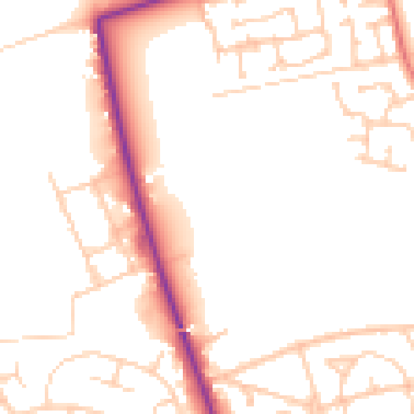
Daytime· 07:00 – 23:00
51.1dB

Night-time· 23:00 – 07:00
41.5dB