11a, Gilwell Avenue, Wirral, CH46 0UB
About 11a
11a is a two-bedroom semi-detached house in Wirral (CH46 0UB). It has a recorded floor area of 68 m² (around 732 sq ft), construction records dating it to 1976-1982 and council tax band A. Tenure is freehold. It has already been extended once and our model flags further extension potential, a sign of buyer flexibility. The latest certificate (June 2022) shows a C (score 72). The recommended improvements would push it to B (score 87).
Across 2003–2022, sale prices on this property compounded at 4.1% per year. Today's modelled estimate of £220,000 is 15.8% above the 2022 sale price. On a £-per-square-foot basis, the last sale (£260/sq ft) was about 67.6% above the typical sold price in the postcode. Last sale on file: £190,000 in December 2022. That sale was during the post-pandemic price surge, when transactions cleared materially above pre-2020 trend.
Know exactly what you're buying at 11a
Before you offer, see what the listing won't tell you, the true value, the red flags and the full history.
Valuation
against the asking price
Risks
planning & flood
Sold prices
similar homes nearby
Trends
the local market
What this property has
Inside
- Bedrooms2
- Bathrooms1
Outside
- Private gardenYes
- ParkingOff road
Building
- TenureFreehold
- Previously extendedYes
- Extension potentialPossible
Energy performance
EPC Rating
Planning history
11a has no planning applications on record.
The full report still covers planning activity across the surrounding area.
Sales history & valuation
Sale price has at least doubled since 2003.
£220,000
Modelled from EPC, postcode comparables and a sale-price growth of 4.1% per year over 20 years.
£190,000
Growth on file: 4.1% per year over 20 years.
Sales timeline
16 December 2022Most recent
£190,000
+123.7%over 19 years28 February 2003
£84,950
Median price across the last 5 sales in CH46 0UB: £185,000 (2024–2021).
Nearby sales in CH46 0UB
Everything we know about 11a, in one report
What it's really worth, what could be wrong, and the planning, sales and area data in full.
- Am I paying too much?
- Is something wrong with it?
- Is the agent's story true?
- Will it hold its value?

Versus other Gilwell Avenue homes
On price per m², 11a stands well clear of the street.
Price per m²
£2,794
Street avg £2,004
Floor Area
68 m²
Street avg 71 m²
Habitable Rooms
4 rooms
Street avg 4 rooms
CO₂ Emissions
2.4 t/year
Street avg 2.9 t/year
Similar properties nearby
1 Inglewood Avenue
CH46 0SB
1 Grampian Way, Moreton
CH46 0QE
1 Haig Avenue
CH46 0PP
1 Briscoe Drive
CH46 0TN
1 Almond Place
CH46 0QD
1 Cranbourne Avenue, Moreton
CH46 0RH
1 Altcar Drive
CH46 0RJ
1 Cobham Road
CH46 0QZ
The neighbourhood at a glance
Reported crime in the wider district is trending notably upward year-on-year.
Crime
4/mo
Rising year-on-year across the wider district.
Nearest stop
0.1 km
Seaforth Drive — bus stop.
Closest school
0.3 km
Moreton Christ Church CofE Primary School. 23 schools nearby.
Go deeper on the local area
The full report breaks down crime, transport links, schools and air quality in depth.
Road noise across the postcode
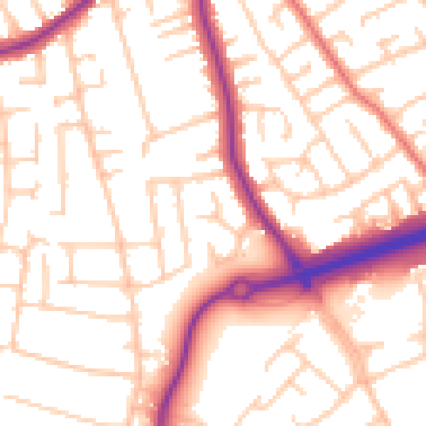
Daytime· 07:00 – 23:00
54.0dB

Night-time· 23:00 – 07:00
44.1dB