1 Akeman Street, Cambridge, CB4 3HE
About 1 Akeman Street
1 Akeman Street is a detached house in Cambridge (CB4 3HE). It has a recorded floor area of 44 m² (around 469 sq ft), construction records dating it to 1930-1949 and council tax band B. At 44 m² this is the 7th smallest of 34 units on EPC record in the building, where floor areas span 33–154 m². The building's EPC ratings span E to B across 34 units on file. The latest certificate (May 2009) shows a C (score 78), near the top of the C band. The latest certificate is from May 2009, so improvements made since then won't be reflected.
At 44 m² it sits well below the postcode median (89 m² across 33 EPCs), making it one of the more compact homes locally.
Know exactly what you're buying at 1 Akeman Street
Before you offer, see what the listing won't tell you, the true value, the red flags and the full history.
Already flagged here
Valuation
against the asking price
Risks
planning & flood
Sold prices
similar homes nearby
Trends
the local market
Energy performance
1 Akeman Street's EPC is over a decade old — improvements since won't be reflected.
EPC Expired
This certificate is over 10 years old and is no longer valid.Expired 28 May 2019
EPC Rating
Planning history
1 Akeman Street has no planning applications on record.
Notable planning nearby
9applications of note in the surrounding area
We flagged 1 thing worth checking at 1 Akeman Street
Independent checks surfaced things a buyer would want to understand before offering. The report explains each one in full, with the underlying data and what to ask.
- Signs of HMO activity in the area
30-day money-back guarantee
Sales history & valuation
1 Akeman Street has no Land Registry sales on file, suggesting it has stayed in the same hands since registration began.
£250,000
Modelled from EPC, postcode comparables.
No sales recorded with HM Land Registry
That can mean the property has never traded since the registry began publishing in 1995, was a new build that hasn't been registered yet, or is held in the same hands long-term.
Median price across the last 5 sales in CB4 3HE: £357,500 (2024–2009).
Nearby sales in CB4 3HE
Everything we know about 1 Akeman Street, in one report
What it's really worth, what could be wrong, and the planning, sales and area data in full.
What we flagged
- Signs of HMO activity in the area

Versus other Akeman Street homes
1 Akeman Street outperforms the street on epc rating by a wide margin.
EPC Rating
78 (C)
Street avg 72 (C)
Floor Area
44 m²
Street avg 40 m²
CO₂ Emissions
1.7 t/year
Street avg 1.6 t/year
Habitable Rooms
2 rooms
Street avg 2 rooms
Similar properties nearby
1 Cooper House, Histon Road
CB4 3LQ
1 Cranwell Court, Histon Road
CB4 3HD
1 Chatsworth Avenue
CB4 3LT
1 Carlyle Road
CB4 3DN
1 Albert Mews, Greens Road
CB4 3EF
1 Chelsea Mews, Bermuda Road
CB4 3JY
1 Belmore Close
CB4 3NN
1 Blanford Walk
CB4 3NQ
The neighbourhood at a glance
Crime
7/mo
Steady year-on-year across the wider district.
Closest school
0.2 km
St Luke's CofE Primary School. 22 schools nearby.
Go deeper on the local area
The full report breaks down crime, transport links, schools and air quality in depth.
Road noise across the postcode
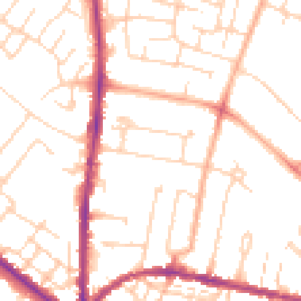
Daytime· 07:00 – 23:00
50.6dB

Night-time· 23:00 – 07:00
40.7dB