Are you a property professional?Get qualified leads from motivated homeowners.
Get started12 Westwood Close, Droitwich, WR9 0BD
About 12 Westwood Close
A plain-English summary derived from public records, EPC certificates, sold prices and local data.
12 Westwood Close is a three-bedroom detached house in Droitwich (WR9 0BD). It has a recorded floor area of 136 m² (around 1464 sq ft), construction records dating it to 1976-1982 and council tax band G. The latest certificate (July 2014) shows a D (score 60), on the cusp of jumping into the C band. The recommended improvements would lift it to B (score 82), a 2-band jump. The latest certificate is from July 2014, so improvements made since then won't be reflected.
Today's modelled estimate of £504,000 sits 73.8% above the 2014 sale of £290,000. Last changed hands 12 years ago, in November 2014. At 136 m² it's 28.4% smaller than the typical home in the postcode (190 m² median across 13 EPCs).
What this property has
Pulled from EPC certificates, claim submissions and our property model. Empty categories are hidden — we only show what's known.
Inside
- Bedrooms3
- Bathrooms2
Energy performance
Every EPC certificate filed against this property — current rating, recorded improvements, and where there's headroom to reach a higher band.
12 Westwood Close's carbon output runs well above what efficient homes in the postcode produce.
EPC Expired
This certificate is over 10 years old and is no longer valid.Expired 09 Jul 2024
Sales history & valuation
Recorded transactions, our model's current estimate, and a quick read on what neighbouring properties have sold for.
Current estimate
See how we calculated this£504,000
Modelled from EPC, postcode comparables.
Last sold (2014)
£290,000
Recorded with HM Land Registry.
Sales timeline
Versus other Westwood Close homes
Four headline reads against 13 similar houses on this street, drawn from the latest EPC and Land Registry data.
Floor Area for 12 Westwood Close lags the street by a wide margin.
Price per m²
£2,132
Street avg £2,519
Floor Area
136 m²
Street avg 184 m²
Habitable Rooms
5 rooms
Similar properties nearby
A handful of close matches in the same postcode area, ranked by likeness on bedrooms, type and floor area.
The neighbourhood at a glance
A condensed read of the local area. Each tile links through to the full breakdown on the Droitwich district page.
Crime
6/mo
Steady year-on-year across the wider district.
Nearest stop
0.6 km
Colford Close — bus stop.
Road noise across the postcode
Modelled day and night-time noise levels around WR9 0BD from Defra's strategic mapping. The pin marks this postcode's centroid.
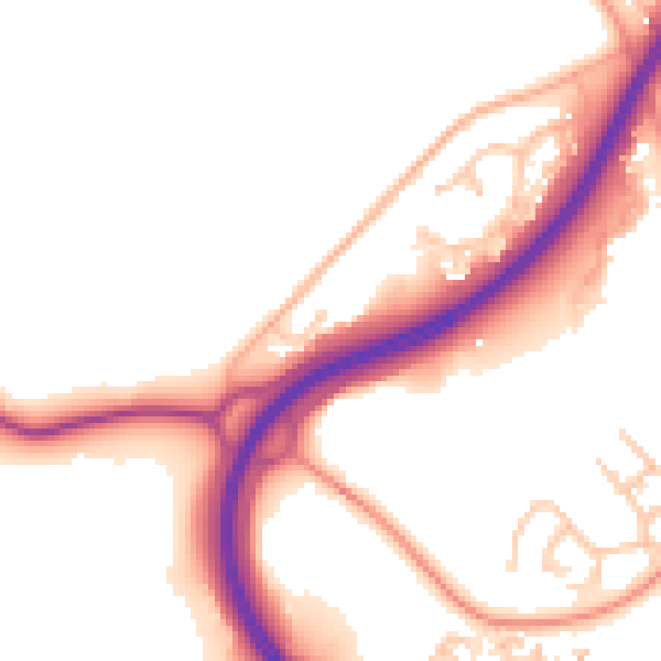
Daytime· 07:00 – 23:00
52.6dB

Everything within walking distance
Schools, transport stops and scenic spots near this property — 37 points of interest in total.
Beautiful places to visit nearby
Curated scenic spots within reach of this postcode, served by Beautifulplaces.ai. Photography and tagging come from their open dataset.
Common questions
The questions buyers, sellers and homeowners most often ask about 12 Westwood Close, Droitwich, WR9 0BD. Each answer is also embedded as structured data for search engines.