Are you a property professional?Get qualified leads from motivated homeowners.
Get startedFlat 1, 42 Ennismore Gardens, London, SW7 1AQ
9 planning records
About Flat 1
A plain-English summary derived from public records, EPC certificates, sold prices and local data.
Flat 1 is a three-bedroom property in London (SW7 1AQ). It has a recorded floor area of 109 m² (around 1173 sq ft), construction records dating it to 1900-1929 and council tax band G. At 109 m² this is the largest unit on EPC record across the building (78–109 m²). The building's EPC ratings span D to C, with this unit at the top. Other recorded features include a basement. Period features are noted in the property record. The latest certificate (July 2025) shows a C (score 70).
At 109 m² the property is well over the postcode median (82 m² across 27 EPCs), placing it in the larger end of the local stock. 9 planning records sit against the property, 6 approved, 2 refused. Past consents include new windows, a conservatory, an extension and a basement excavation, meaningful when judging how the property has evolved. The record references listed-building consent, which constrain future alterations. Today's modelled estimate of £1,988,000 is 30.8% above the 2017 sale price. On a £-per-square-foot basis, the last sale (£1,296/sq ft) was about 25.8% above the typical sold price in the postcode. 9 years since the last transfer (September 2017).
What this property has
Pulled from EPC certificates, claim submissions and our property model. Empty categories are hidden — we only show what's known.
Inside
- Bedrooms3
- Bathrooms2
- BasementYes
Outside
- Private garden
Energy performance
Every EPC certificate filed against this property — current rating, recorded improvements, and where there's headroom to reach a higher band.
EPC Rating
A
B
C
C70
D
E
F
G
Main Heating
Electric & Gas
Main Fuel
Gas
Hot Water
Good
Windows
Very Poor
CO2 Emissions
3.1 t/year
Occupancy
Owner Occupied
Planning history
Applications and permits filed against Flat 1, 42 Ennismore Gardens, London, SW7 1AQ, sourced from the PlanIt planning register.
Flat 1 has 2 separate extension applications on the council record.
- Jul 2019RenovationFullGranted
Replacement of two windows at front basement.
Sales history & valuation
Recorded transactions, our model's current estimate, and a quick read on what neighbouring properties have sold for.
Flat 1 valuation sits well clear of the typical sold price in this postcode.
Current estimate
See how we calculated this£1,988,000
Modelled from EPC, postcode comparables.
Last sold (2017)
£1,520,000
Recorded with HM Land Registry.
Sales timeline
Full property reportLaunch offer · 33% off
The complete analysis of Flat 1, 42 Ennismore Gardens, London, SW7 1AQ
Everything we know about this property, compiled into one in-depth, downloadable report.
Detailed AI analysis
Versus other Ennismore Gardens homes
Four headline reads against 26 similar flats on this street, drawn from the latest EPC and Land Registry data.
On habitable rooms, Flat 1 stands well clear of the street.
Price per m²
£13,945
Street avg £14,022
Floor Area
109 m²
Street avg 82 m²
Habitable Rooms
4 rooms
Similar properties nearby
A handful of close matches in the same postcode area, ranked by likeness on bedrooms, type and floor area.
The neighbourhood at a glance
A condensed read of the local area. Each tile links through to the full breakdown on the London district page.
Rail-style transport is unusually close for this postcode.
Crime
10/mo
Rising year-on-year across the wider district.
Nearest stop
0.2 km
Brompton Square — bus stop.
Road noise across the postcode
Modelled day and night-time noise levels around SW7 1AQ from Defra's strategic mapping. The pin marks this postcode's centroid.
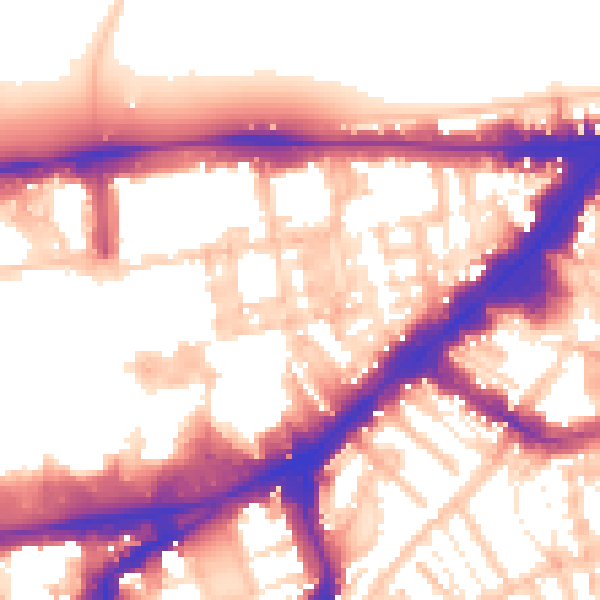
Daytime· 07:00 – 23:00
57.2dB

Everything within walking distance
Schools, transport stops and scenic spots near this property — 91 points of interest in total.
Common questions
The questions buyers, sellers and homeowners most often ask about Flat 1, 42 Ennismore Gardens, London, SW7 1AQ. Each answer is also embedded as structured data for search engines.