Are you a property professional?Get qualified leads from motivated homeowners.
Get startedFlat 5, 18 Clarendon Drive, London, SW15 1AA
About Flat 5
A plain-English summary derived from public records, EPC certificates, sold prices and local data.
Flat 5 is a one-bedroom semi-detached house in London (SW15 1AA). It has a recorded floor area of 44 m² (around 474 sq ft), construction records dating it to 1900-1929 and council tax band D. At 44 m² this is the largest unit on EPC record across the building (30–44 m²). The building's EPC ratings span E to C, with this unit at the bottom. On EPC score it ranks last in the building (53 versus a best of 73). Period features are noted in the property record. The latest certificate (June 2021) shows an E (score 53), well below the UK norm with real room to improve. The rating has held steady at E across 2 certificates since January 2009. The recommended improvements would push it to D (score 67).
At 44 m² it sits well below the postcode median (122 m² across 11 EPCs), making it one of the more compact homes locally. Today's modelled estimate of £434,000 is 13.5% above the 2022 sale price. On a £-per-square-foot basis, the last sale (£808/sq ft) was about 67.7% above the typical sold price in the postcode. Last sale on file: £382,500 in October 2022. That sale was during the post-pandemic price surge, when transactions cleared materially above pre-2020 trend.
What this property has
Pulled from EPC certificates, claim submissions and our property model. Empty categories are hidden — we only show what's known.
Inside
- Bedrooms1
Building
- Period featuresYes
Energy performance
Every EPC certificate filed against this property — current rating, recorded improvements, and where there's headroom to reach a higher band.
Current Certificate(1 of 2)
Jun 2021
EPC Rating
A
B
C
D
E
E53
F
G
Main Heating
Gas
Main Fuel
Gas
Hot Water
Good
Windows
Very Poor
CO2 Emissions
3.1 t/year
Occupancy
Rented
Sales history & valuation
Recorded transactions, our model's current estimate, and a quick read on what neighbouring properties have sold for.
The latest sale landed in the post-pandemic price surge — useful context when reading the figure.
Current estimate
See how we calculated this£434,000
Modelled from EPC, postcode comparables.
Last sold (2022)
£382,500
Recorded with HM Land Registry.
Sales timeline
Versus other Clarendon Drive homes
Four headline reads against 5 similar flats on this street, drawn from the latest EPC and Land Registry data.
Price per m² for Flat 5 runs comfortably ahead of the street norm.
Price per m²
£8,693
Street avg £4,176
Floor Area
44 m²
Street avg 49 m²
Habitable Rooms
3 rooms
Similar properties nearby
A handful of close matches in the same postcode area, ranked by likeness on bedrooms, type and floor area.
The neighbourhood at a glance
A condensed read of the local area. Each tile links through to the full breakdown on the London district page.
Rail-style transport is unusually close for this postcode.
Crime
7/mo
Rising year-on-year across the wider district.
Nearest stop
0.2 km
Putney Methodist Church — bus stop.
Road noise across the postcode
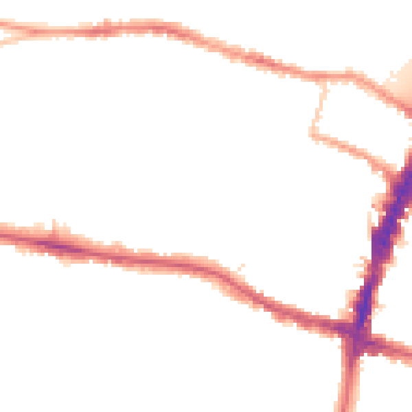
Modelled day and night-time noise levels around SW15 1AA from Defra's strategic mapping. The pin marks this postcode's centroid.

Daytime· 07:00 – 23:00
54.4dB
Everything within walking distance
Schools, transport stops and scenic spots near this property — 86 points of interest in total.
Beautiful places to visit nearby
Curated scenic spots within reach of this postcode, served by Beautifulplaces.ai. Photography and tagging come from their open dataset.
Common questions
The questions buyers, sellers and homeowners most often ask about Flat 5, 18 Clarendon Drive, London, SW15 1AA. Each answer is also embedded as structured data for search engines.