Are you a property professional?Get qualified leads from motivated homeowners.
Get started15 Conholt Road, Andover, SP10 2HR
1 planning record
About 15 Conholt Road
A plain-English summary derived from public records, EPC certificates, sold prices and local data.
15 Conholt Road is a two-bedroom detached house in Andover (SP10 2HR). It has a recorded floor area of 88 m² (around 947 sq ft), construction records dating it to 1950-1966 and council tax band E. The latest certificate (June 2023) shows a D (score 60), on the cusp of jumping into the C band. The recommended improvements would lift it to B (score 83), a 2-band jump. Other recorded features include a conservatory and attached land beyond the plot.
Today's modelled estimate of £402,000 is 27.6% above the 2024 sale price. On a £-per-square-foot basis, the last sale (£333/sq ft) was about 22.9% above the typical sold price in the postcode. Last sale on file: £315,000 in March 2024. One historical planning record sits against the property in 2024.
What this property has
Pulled from EPC certificates, claim submissions and our property model. Empty categories are hidden — we only show what's known.
Inside
- Bedrooms2
- Bathrooms1
- Dining roomYes
- ConservatoryYes
Energy performance
Every EPC certificate filed against this property — current rating, recorded improvements, and where there's headroom to reach a higher band.
Recommended upgrades on file would lift this property by multiple EPC bands.
EPC Rating
A
B
C
D
D60
E
F
G
Main Heating
Gas
Main Fuel
Gas
Hot Water
Good
Windows
Average
CO2 Emissions
4.4 t/year
Occupancy
Owner Occupied
Planning history
Applications and permits filed against 15 Conholt Road, Andover, SP10 2HR, sourced from the PlanIt planning register.
- Sept 2024PorchFullPERMISSION subject to conditions & notes
Extension: Single storey
Construct front and side single storey extension to create new front entrance, convert and extend garage to ancillary annex, addition of ramp and replacement windows
Sales history & valuation
Recorded transactions, our model's current estimate, and a quick read on what neighbouring properties have sold for.
15 Conholt Road valuation sits well clear of the typical sold price in this postcode.
Current estimate
See how we calculated this£402,000
Modelled from EPC, postcode comparables.
Last sold (2024)
£315,000
Recorded with HM Land Registry.
Sales timeline
Launch offer · 33% off
Buying 15 Conholt Road, Andover, SP10 2HR? Know what you're getting into
Everything a buyer needs to know about this property, compiled into one in-depth report so there are no surprises after you offer.
Spot red flags before you buy
An AI-written breakdown of everything that matters
Versus other Conholt Road homes
Four headline reads against 18 similar houses on this street, drawn from the latest EPC and Land Registry data.
On years held, 15 Conholt Road runs well behind the street norm.
Price per m²
£3,580
Street avg £3,431
Floor Area
88 m²
Street avg 110 m²
Habitable Rooms
4 rooms
Street avg 5 rooms
Similar properties nearby
A handful of close matches in the same postcode area, ranked by likeness on bedrooms, type and floor area.
The neighbourhood at a glance
A condensed read of the local area. Each tile links through to the full breakdown on the Andover district page.
Crime
4/mo
Steady year-on-year across the wider district.
Nearest stop
0.1 km
Anglesey Close — bus stop.
Road noise across the postcode
Modelled day and night-time noise levels around SP10 2HR from Defra's strategic mapping. The pin marks this postcode's centroid.
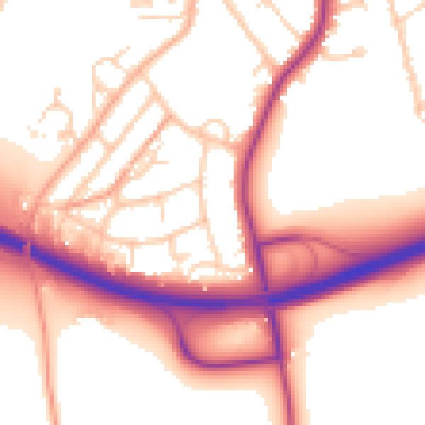
Daytime· 07:00 – 23:00
55.3dB

Everything within walking distance
Schools, transport stops and scenic spots near this property — 43 points of interest in total.
Common questions
The questions buyers, sellers and homeowners most often ask about 15 Conholt Road, Andover, SP10 2HR. Each answer is also embedded as structured data for search engines.
