Are you a property professional?Get qualified leads from motivated homeowners.
Get started6 Old Hall Farm, High Street, Kimberworth, Rotherham, S61 2BF
3 sales on record
About 6 Old Hall Farm
A plain-English summary derived from public records, EPC certificates, sold prices and local data.
6 Old Hall Farm is a five-bedroom semi-detached house in Kimberworth, Rotherham, Rotherham (S61 2BF). It has a recorded floor area of 167 m² (around 1798 sq ft), construction records dating it to 1996-2002 and council tax band D. The latest certificate (December 2013) shows a C (score 70). The recommended improvements would push it to B (score 82). The latest certificate is from December 2013, so improvements made since then won't be reflected. Period features are noted in the property record.
Sale prices here have outpaced Rotherham HPI: 21.7% per year against 0% for the wider region. Today's modelled estimate of £384,000 is 28% above the 2014 sale price. On a £-per-square-foot basis, the last sale (£167/sq ft) was about 97.7% above the typical sold price in the postcode. Last sold in July 2014, so it's been off the market for around 12 years.
What this property has
Pulled from EPC certificates, claim submissions and our property model. Empty categories are hidden — we only show what's known.
Inside
- Bedrooms5
- Bathrooms2
- FireplaceYes
Outside
- Private garden
Energy performance
Every EPC certificate filed against this property — current rating, recorded improvements, and where there's headroom to reach a higher band.
6 Old Hall Farm's EPC is over a decade old — improvements since won't be reflected.
EPC Expired
This certificate is over 10 years old and is no longer valid.Expired 06 Dec 2023
Sales history & valuation
Recorded transactions, our model's current estimate, and a quick read on what neighbouring properties have sold for.
6 Old Hall Farm has more than quadrupled in price since its earliest registered sale in 2001.
Current estimate
See how we calculated this£384,000
Modelled from EPC, postcode comparables and a sale-price growth of 21.7% per year over 13 years.
Last sold (2014)
£300,000
Growth on file: 21.7% per year over 13 years.
Sales timeline
Versus other High Street homes
Four headline reads against 5 similar houses on this street, drawn from the latest EPC and Land Registry data.
Floor Area for 6 Old Hall Farm runs comfortably ahead of the street norm.
Price per m²
£1,796
Street avg £1,548
Floor Area
167 m²
Street avg 170 m²
Habitable Rooms
7 rooms
Similar properties nearby
A handful of close matches in the same postcode area, ranked by likeness on bedrooms, type and floor area.
The neighbourhood at a glance
A condensed read of the local area. Each tile links through to the full breakdown on the Rotherham district page.
Daytime road noise here sits well below conversation level — a quiet pocket of the postcode.
Crime
6/mo
Steady year-on-year across the wider district.
Nearest stop
0.1 km
Road noise across the postcode
Modelled day and night-time noise levels around S61 2BF from Defra's strategic mapping. The pin marks this postcode's centroid.
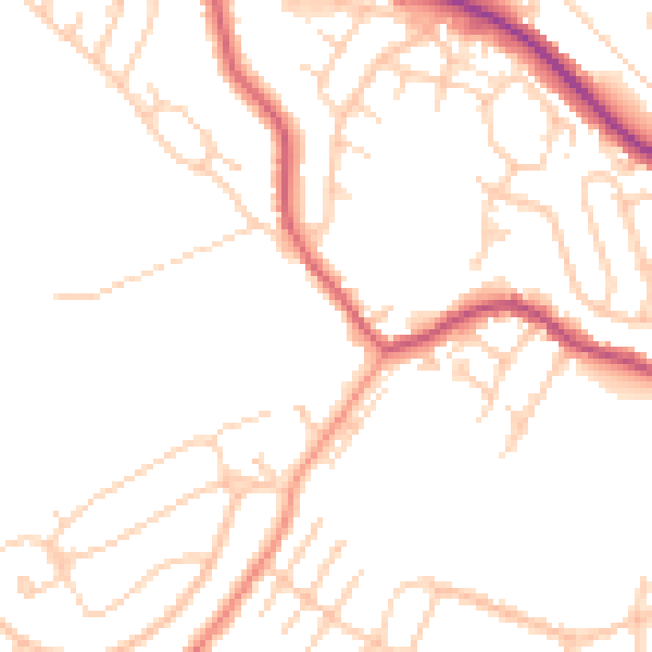
Daytime· 07:00 – 23:00
48.4dB

Everything within walking distance
Schools, transport stops and scenic spots near this property — 48 points of interest in total.
Beautiful places to visit nearby
Curated scenic spots within reach of this postcode, served by Beautifulplaces.ai. Photography and tagging come from their open dataset.
Common questions
The questions buyers, sellers and homeowners most often ask about 6 Old Hall Farm, High Street, Kimberworth, Rotherham, S61 2BF. Each answer is also embedded as structured data for search engines.