Are you a property professional?Get qualified leads from motivated homeowners.
Get started3 Maritime Way, St Marys Island, Chatham, ME4 3ER
4 sales on record
About 3 Maritime Way
A plain-English summary derived from public records, EPC certificates, sold prices and local data.
3 Maritime Way is a three-bedroom mid-terrace house in St. Marys Island, Chatham, Chatham (ME4 3ER). It has a recorded floor area of 89 m² (around 958 sq ft), construction records dating it to 1996-2002 and council tax band D. The latest certificate (January 2010) shows a C (score 73). The latest certificate is from January 2010, so improvements made since then won't be reflected.
Sale prices here have outpaced England HPI: 4% per year against 0% for the wider region. Today's modelled estimate of £328,000 is 47.1% above the 2015 sale price. On a £-per-square-foot basis, the last sale (£233/sq ft) was about 68.2% above the typical sold price in the postcode. Last sold in April 2015, so it's been off the market for around 11 years. Across the public record there are 4 sales, relatively high churn for a single property.
What this property has
Pulled from EPC certificates, claim submissions and our property model. Empty categories are hidden — we only show what's known.
Inside
- Bedrooms3
- Dining roomYes
- EnsuiteYes
Outside
- Parking
Energy performance
Every EPC certificate filed against this property — current rating, recorded improvements, and where there's headroom to reach a higher band.
3 Maritime Way's EPC is over a decade old — improvements since won't be reflected.
EPC Expired
This certificate is over 10 years old and is no longer valid.Expired 28 Jan 2020
Sales history & valuation
Recorded transactions, our model's current estimate, and a quick read on what neighbouring properties have sold for.
3 Maritime Way valuation sits well clear of the typical sold price in this postcode.
Current estimate
See how we calculated this£328,000
Modelled from EPC, postcode comparables and a sale-price growth of 4.0% per year over 14 years.
Last sold (2015)
£223,000
Growth on file: 4.0% per year over 14 years.
Sales timeline
Full property reportLaunch offer · 33% off
The complete analysis of 3 Maritime Way, St Marys Island, Chatham, ME4 3ER
Everything we know about this property, compiled into one in-depth, downloadable report.
Detailed AI analysis
Similar properties nearby
A handful of close matches in the same postcode area, ranked by likeness on bedrooms, type and floor area.
The neighbourhood at a glance
A condensed read of the local area. Each tile links through to the full breakdown on the Chatham district page.
Reported crime in the wider district is trending notably upward year-on-year.
Crime
18/mo
Rising year-on-year across the wider district.
Nearest stop
0.1 km
Ship and Trades — bus stop.
Road noise across the postcode
Modelled day and night-time noise levels around ME4 3ER from Defra's strategic mapping. The pin marks this postcode's centroid.
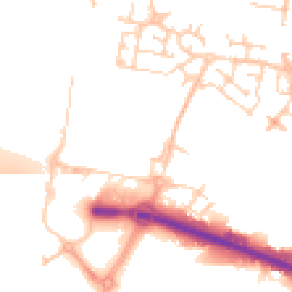
Daytime· 07:00 – 23:00
50.7dB

Everything within walking distance
Schools, transport stops and scenic spots near this property — 57 points of interest in total.
Common questions
The questions buyers, sellers and homeowners most often ask about 3 Maritime Way, St Marys Island, Chatham, ME4 3ER. Each answer is also embedded as structured data for search engines.