Are you a property professional?Get qualified leads from motivated homeowners.
Get started27 Forfar Road, Liverpool, L13 8DU
About 27 Forfar Road
A plain-English summary derived from public records, EPC certificates, sold prices and local data.
27 Forfar Road is an end-of-terrace house in Liverpool (L13 8DU). It has a recorded floor area of 50 m² (around 538 sq ft), construction records dating it to before 1900 and council tax band A. The latest certificate (December 2018) shows a D (score 59), a step below the typical UK home. The recommended improvements would lift it to B (score 87), a 2-band jump.
Sale prices here have outpaced Liverpool HPI: 7.5% per year against 0% for the wider region. Today's modelled estimate of £110,000 is 31% above the 2023 sale price. On a £-per-square-foot basis, the last sale (£156/sq ft) was about 68.1% above the typical sold price in the postcode. Sold August 2023 for £84,000.
Energy performance
Every EPC certificate filed against this property — current rating, recorded improvements, and where there's headroom to reach a higher band.
Recommended upgrades on file would lift this property by multiple EPC bands.
EPC Rating
A
B
C
D
D59
E
F
G
Main Heating
Gas
Main Fuel
Gas
Hot Water
Good
Windows
Average
CO2 Emissions
3.1 t/year
Occupancy
Rented
Sales history & valuation
Recorded transactions, our model's current estimate, and a quick read on what neighbouring properties have sold for.
Price for 27 Forfar Road has grown more than fourfold since the 2003 starting point.
Current estimate
See how we calculated this£110,000
Modelled from EPC, postcode comparables and a sale-price growth of 7.5% per year over 20 years.
Last sold (2023)
£84,000
Growth on file: 7.5% per year over 20 years.
Sales timeline
Full property reportLaunch offer · 33% off
The complete analysis of 27 Forfar Road, Liverpool, L13 8DU
Everything we know about this property, compiled into one in-depth, downloadable report.
Detailed AI analysis
Versus other Forfar Road homes
Four headline reads against 39 similar houses on this street, drawn from the latest EPC and Land Registry data.
27 Forfar Road is notably below the street on years held.
Price per m²
£1,680
Street avg £1,221
Floor Area
50 m²
Street avg 58 m²
Habitable Rooms
3 rooms
Street avg 3 rooms
Similar properties nearby
A handful of close matches in the same postcode area, ranked by likeness on bedrooms, type and floor area.
The neighbourhood at a glance
A condensed read of the local area. Each tile links through to the full breakdown on the Liverpool district page.
Crime
6/mo
Steady year-on-year across the wider district.
Nearest stop
0.4 km
Maiden Lane — bus stop.
Road noise across the postcode
Modelled day and night-time noise levels around L13 8DU from Defra's strategic mapping. The pin marks this postcode's centroid.
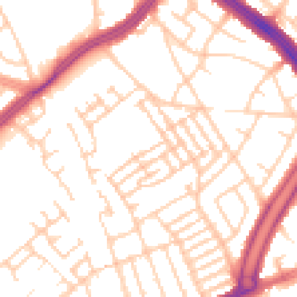
Daytime· 07:00 – 23:00
52.4dB

Everything within walking distance
Schools, transport stops and scenic spots near this property — 85 points of interest in total.
Common questions
The questions buyers, sellers and homeowners most often ask about 27 Forfar Road, Liverpool, L13 8DU. Each answer is also embedded as structured data for search engines.