Are you a property professional?Get qualified leads from motivated homeowners.
Get started32 Burdett Close, Sidcup, DA14 5LF
6 sales on record
About 32 Burdett Close
A plain-English summary derived from public records, EPC certificates, sold prices and local data.
32 Burdett Close is a semi-detached house in Sidcup (DA14 5LF). It has a recorded floor area of 72 m² (around 775 sq ft), construction records dating it to 1950-1966 and council tax band B. The latest certificate (December 2017) shows a C (score 76), near the top of the C band. When first surveyed in February 2013 the rating was D, the property has climbed 1 band since. Between certificates, roof efficiency went from Very Poor to Good and lighting went from Very Poor to Very Good; while wall efficiency dropped from Good to Poor. At 72 m² this is the 23rd smallest of 34 units on EPC record in the building, where floor areas span 42–155 m². The building's EPC ratings span E to B across 34 units on file.
Sale prices here have outpaced England HPI: 9% per year against 0% for the wider region. On a £-per-square-foot basis, the last sale (£277/sq ft) was about 40.8% above the typical sold price in the postcode. Last changed hands 9 years ago, in October 2017. Across the public record there are 6 sales, relatively high churn for a single property.
Energy performance
Every EPC certificate filed against this property — current rating, recorded improvements, and where there's headroom to reach a higher band.
Current Certificate(1 of 2)
Dec 2017
EPC Rating
A
B
C
C76
D
E
F
G
Main Heating
Gas
Main Fuel
Gas
Hot Water
Good
Windows
Average
CO2 Emissions
1.9 t/year
Occupancy
Rented
Sales history & valuation
Recorded transactions, our model's current estimate, and a quick read on what neighbouring properties have sold for.
Price for 32 Burdett Close has grown more than fourfold since the 1995 starting point.
Current estimate
See how we calculated this£229,000
Modelled from EPC, postcode comparables and a sale-price growth of 9.0% per year over 23 years.
Last sold (2017)
£215,000
Growth on file: 9.0% per year over 23 years.
Sales timeline
Launch offer · 33% off
Buying 32 Burdett Close, Sidcup, DA14 5LF? Know what you're getting into
Everything a buyer needs to know about this property, compiled into one in-depth report so there are no surprises after you offer.
Spot red flags before you buy
An AI-written breakdown of everything that matters
Versus other Burdett Close homes
Four headline reads against 22 similar flats on this street, drawn from the latest EPC and Land Registry data.
32 Burdett Close outperforms the street on floor area by a wide margin.
EPC Rating
76 (C)
Street avg 71 (C)
Floor Area
72 m²
Street avg 64 m²
CO₂ Emissions
1.9 t/year
Similar properties nearby
A handful of close matches in the same postcode area, ranked by likeness on bedrooms, type and floor area.
The neighbourhood at a glance
A condensed read of the local area. Each tile links through to the full breakdown on the Sidcup district page.
Crime
4/mo
Steady year-on-year across the wider district.
Nearest stop
0.1 km
Ellenborough Road — bus stop.
Road noise across the postcode
Modelled day and night-time noise levels around DA14 5LF from Defra's strategic mapping. The pin marks this postcode's centroid.
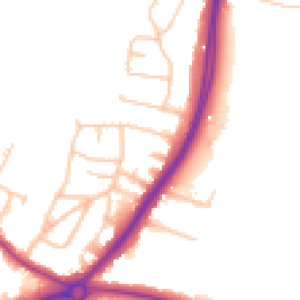
Daytime· 07:00 – 23:00
51.3dB

Everything within walking distance
Schools, transport stops and scenic spots near this property — 49 points of interest in total.
Common questions
The questions buyers, sellers and homeowners most often ask about 32 Burdett Close, Sidcup, DA14 5LF. Each answer is also embedded as structured data for search engines.
