Are you a property professional?Get qualified leads from motivated homeowners.
Get started58 Hatherley Road, Sidcup, DA14 4AJ
About 58 Hatherley Road
A plain-English summary derived from public records, EPC certificates, sold prices and local data.
58 Hatherley Road is a two-bedroom semi-detached house in Sidcup (DA14 4AJ). It has a recorded floor area of 49 m² (around 527 sq ft), construction records dating it to 1967-1975 and council tax band C. The latest certificate (May 2014) shows a D (score 58), a step below the typical UK home. The recommended improvements would push it to C (score 76). Main heating runs on electricity. The latest certificate is from May 2014, so improvements made since then won't be reflected.
Today's modelled estimate of £324,000 is 48.6% above the 2014 sale price. On a £-per-square-foot basis, the last sale (£413/sq ft) was about 60% above the typical sold price in the postcode. 12 years since the last transfer (November 2014).
What this property has
Pulled from EPC certificates, claim submissions and our property model. Empty categories are hidden — we only show what's known.
Inside
- Bedrooms2
- Bathrooms1
Outside
- Private gardenrear
- Garage
Energy performance
Every EPC certificate filed against this property — current rating, recorded improvements, and where there's headroom to reach a higher band.
58 Hatherley Road's EPC is over a decade old — improvements since won't be reflected.
EPC Expired
This certificate is over 10 years old and is no longer valid.Expired 13 May 2024
Sales history & valuation
Recorded transactions, our model's current estimate, and a quick read on what neighbouring properties have sold for.
58 Hatherley Road valuation sits well clear of the typical sold price in this postcode.
Current estimate
See how we calculated this£324,000
Modelled from EPC, postcode comparables.
Last sold (2014)
£218,000
Recorded with HM Land Registry.
Sales timeline
Launch offer · 33% off
Buying 58 Hatherley Road, Sidcup, DA14 4AJ? Know what you're getting into
Everything a buyer needs to know about this property, compiled into one in-depth report so there are no surprises after you offer.
Spot red flags before you buy
An AI-written breakdown of everything that matters
Versus other Hatherley Road homes
Four headline reads against 18 similar flats on this street, drawn from the latest EPC and Land Registry data.
Price per m² for 58 Hatherley Road runs comfortably ahead of the street norm.
Price per m²
£4,449
Street avg £3,143
Floor Area
49 m²
Street avg 51 m²
Habitable Rooms
3 rooms
Similar properties nearby
A handful of close matches in the same postcode area, ranked by likeness on bedrooms, type and floor area.
The neighbourhood at a glance
A condensed read of the local area. Each tile links through to the full breakdown on the Sidcup district page.
Rail-style transport is unusually close for this postcode.
Crime
4/mo
Steady year-on-year across the wider district.
Nearest stop
0.2 km
Hatherley Crescent / Sidcup Station — bus stop.
Road noise across the postcode
Modelled day and night-time noise levels around DA14 4AJ from Defra's strategic mapping. The pin marks this postcode's centroid.
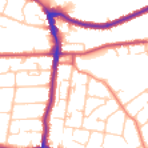
Daytime· 07:00 – 23:00
52.2dB

Everything within walking distance
Schools, transport stops and scenic spots near this property — 61 points of interest in total.
Common questions
The questions buyers, sellers and homeowners most often ask about 58 Hatherley Road, Sidcup, DA14 4AJ. Each answer is also embedded as structured data for search engines.
