Are you a property professional?Get qualified leads from motivated homeowners.
Get started26 Arley Court, Wrenbury Drive, Northwich, CW9 8RX
About 26 Arley Court
A plain-English summary derived from public records, EPC certificates, sold prices and local data.
26 Arley Court is a two-bedroom end-of-terrace house in Northwich (CW9 8RX). It has a recorded floor area of 57 m² (around 614 sq ft), construction records dating it to 2003-2006 and council tax band C. At 57 m² this is the 6th smallest of 43 units on EPC record in the building, where floor areas span 50–100 m². The building's EPC ratings span C to B, with this unit at the bottom. The latest certificate (June 2021) shows a C (score 78), near the top of the C band. Earlier certificates rated it B (June 2010); the latest reading is one band lower. Between certificates, lighting dropped from Very Good to Good.
It hasn't traded since October 2005, a hold of 21 years that's notably long for the area.
What this property has
Pulled from EPC certificates, claim submissions and our property model. Empty categories are hidden — we only show what's known.
Inside
- Bedrooms2
- Bathrooms1
Outside
- Parkingallocated
Building
Energy performance
Every EPC certificate filed against this property — current rating, recorded improvements, and where there's headroom to reach a higher band.
26 Arley Court's carbon output is low for the local stock.
Current Certificate(1 of 2)
Jun 2021
EPC Rating
A
B
C
C78
D
E
F
G
Main Heating
Gas
Main Fuel
Gas
Hot Water
Good
Windows
Good
CO2 Emissions
1.4 t/year
Occupancy
Rented
Sales history & valuation
Recorded transactions, our model's current estimate, and a quick read on what neighbouring properties have sold for.
Current estimate
See how we calculated this£127,000
Modelled from EPC, postcode comparables.
Last sold (2005)
£121,950
Recorded with HM Land Registry.
Sales timeline
Versus other Wrenbury Drive homes
Four headline reads against 42 similar flats on this street, drawn from the latest EPC and Land Registry data.
On years held, 26 Arley Court stands well clear of the street.
Price per m²
£2,139
Street avg £1,928
Floor Area
57 m²
Street avg 62 m²
Habitable Rooms
3 rooms
Similar properties nearby
A handful of close matches in the same postcode area, ranked by likeness on bedrooms, type and floor area.
The neighbourhood at a glance
A condensed read of the local area. Each tile links through to the full breakdown on the Northwich district page.
Daytime road noise here sits well below conversation level — a quiet pocket of the postcode.
Crime
2/mo
Steady year-on-year across the wider district.
Nearest stop
0.3 km
Road noise across the postcode
Modelled day and night-time noise levels around CW9 8RX from Defra's strategic mapping. The pin marks this postcode's centroid.
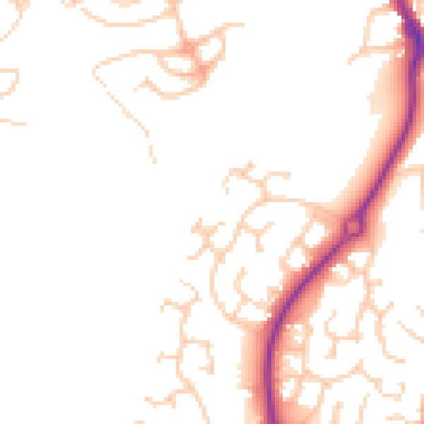
Daytime· 07:00 – 23:00
47.8dB

Everything within walking distance
Schools, transport stops and scenic spots near this property — 48 points of interest in total.
Beautiful places to visit nearby
Curated scenic spots within reach of this postcode, served by Beautifulplaces.ai. Photography and tagging come from their open dataset.
Common questions
The questions buyers, sellers and homeowners most often ask about 26 Arley Court, Wrenbury Drive, Northwich, CW9 8RX. Each answer is also embedded as structured data for search engines.