Are you a property professional?Get qualified leads from motivated homeowners.
Get started14 Albany Road, Coventry, CV5 6JQ
4 planning records
About 14 Albany Road
A plain-English summary derived from public records, EPC certificates, sold prices and local data.
14 Albany Road is a ten-bedroom end-of-terrace house in Coventry (CV5 6JQ). It has a recorded floor area of 230 m² (around 2476 sq ft), construction records dating it to 1900-1929 and council tax band D. The latest certificate (February 2026) shows a D (score 63), on the cusp of jumping into the C band. The rating has held steady at D across 3 certificates since August 2009. Between certificates, roof efficiency dropped from Good to Very Poor and window efficiency dropped from Average to Poor. The recommended improvements would lift it to B (score 81), a 2-band jump. This certificate was lodged in the last six months, so the rating reflects current condition. Period features are noted in the property record.
Sale prices here have outpaced Coventry HPI: 9.5% per year against 0% for the wider region. Today's modelled estimate of £529,000 is 32.3% above the 2014 sale price. On a £-per-square-foot basis, the last sale (£162/sq ft) was about 39.1% above the typical sold price in the postcode. At 230 m² the property is well over the postcode median (68 m² across 19 EPCs), placing it in the larger end of the local stock. 10 bedrooms is on the larger side for this postcode, where 4 is the typical count. On the market in September 2014 and unlisted since — roughly 12 years. 4 planning records sit against the property, 0 approved, 4 refused.
What this property has
Pulled from EPC certificates, claim submissions and our property model. Empty categories are hidden — we only show what's known.
Inside
- Bedrooms10
- Bathrooms3
- CloakroomYes
Building
- Heating system
Energy performance
Every EPC certificate filed against this property — current rating, recorded improvements, and where there's headroom to reach a higher band.
14 Albany Road's carbon output runs well above what efficient homes in the postcode produce.
Current Certificate(1 of 3)
Feb 2026
EPC Rating
A
B
C
D
D63
E
F
G
Main Heating
Gas
Main Fuel
Gas
Hot Water
Good
Windows
Poor
CO2 Emissions
9.2 t/year
Occupancy
Rented
Planning history
Applications and permits filed against 14 Albany Road, Coventry, CV5 6JQ, sourced from the PlanIt planning register.
- Oct 2020Change of UseFullWithdrawn
Application for a change of use from a shop (Use Class A1) & Residential (Use Class C3) to a single dwellinghouse (Use Class C3).
Sales history & valuation
Recorded transactions, our model's current estimate, and a quick read on what neighbouring properties have sold for.
Latest sale on 14 Albany Road was the highest on Land Registry record across the postcode.
Current estimate
See how we calculated this£529,000
Modelled from EPC, postcode comparables and a sale-price growth of 9.5% per year over 13 years.
Last sold (2014)
£400,000
Growth on file: 9.5% per year over 13 years.
Sales timeline
Versus other Albany Road homes
Four headline reads against 10 similar houses on this street, drawn from the latest EPC and Land Registry data.
14 Albany Road outperforms the street on price per m² by a wide margin.
Price per m²
£1,739
Street avg £1,024
Floor Area
230 m²
Street avg 186 m²
Habitable Rooms
12 rooms
Similar properties nearby
A handful of close matches in the same postcode area, ranked by likeness on bedrooms, type and floor area.
The neighbourhood at a glance
A condensed read of the local area. Each tile links through to the full breakdown on the Coventry district page.
Rail-style transport is unusually close for this postcode.
Crime
4/mo
Steady year-on-year across the wider district.
Nearest stop
0.8 km
Coventry Rail Station — railway station.
Road noise across the postcode
Modelled day and night-time noise levels around CV5 6JQ from Defra's strategic mapping. The pin marks this postcode's centroid.
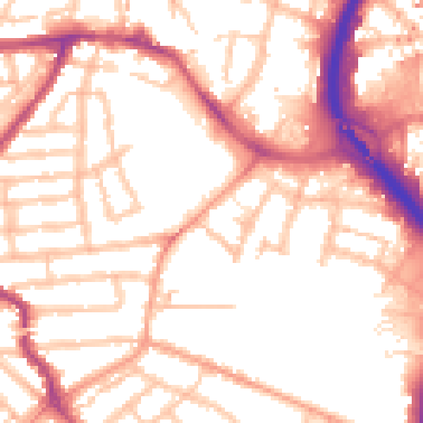
Daytime· 07:00 – 23:00
54.1dB

Everything within walking distance
Schools, transport stops and scenic spots near this property — 41 points of interest in total.
Beautiful places to visit nearby
Curated scenic spots within reach of this postcode, served by Beautifulplaces.ai. Photography and tagging come from their open dataset.
Common questions
The questions buyers, sellers and homeowners most often ask about 14 Albany Road, Coventry, CV5 6JQ. Each answer is also embedded as structured data for search engines.