Are you a property professional?Get qualified leads from motivated homeowners.
Get started1 Alfells Road, Elmstead, Colchester, CO7 7EH
This property in Elmstead, Colchester, Colchester. Explore detailed information about this Elmstead, Colchester property including energy performance, price history, local schools, transport links and crime statistics.
Property Type
Property
Bedrooms
—
Floor Area
— m²
Council Tax
Band C
Get started
Ready to take the next step? Find the right professionals for your property journey.
Energy Performance
EPC rating and efficiency details
A
B
C
D
E
F
G
No EPC on record
This property doesn't have an Energy Performance Certificate yet. An EPC helps us give a more accurate valuation and is required to sell or let.
Price & History
Transactions and market trends
Transaction history
No sales history found
Nearby in CO7 7EH
3 Alfells Road Elmstead Colchester CO7 7EH
Nov 2025
£300,000
14 Alfells Road Elmstead Colchester CO7 7EH
Apr 2023
£350,000
16 Alfells Road Elmstead Colchester CO7 7EH
Mar 2023
£335,500
4 Alfells Road Elmstead Colchester CO7 7EH
Dec 2021
£240,000
20 Alfells Road Elmstead Colchester CO7 7EH
Jun 2019
£310,000
18 Alfells Road Elmstead Colchester CO7 7EH
Jul 2015
£208,000
1 / 2
House Price Index
Colchester+0.4%
95.3
Jan 26
UK HPI from HM Land Registry. Baseline: Jan 2015 = 100.
How This Property Compares on Alfells Road
See how this property stacks up against others nearby
Not enough similar properties in this postcode to make meaningful comparisons.
Get alerts for CO7 7EH
New sales, price changes, and market updates in this area
About Elmstead, Colchester
This property is located in Elmstead, a village in the civil parish of Elmstead, within the Tendring district of Essex. It sits on the A133 road, providing direct links to Colchester to the west and Clacton-on-Sea to the south‑east.
Elmstead Market is a village in the civil parish of Elmstead, in the Tendring district of Essex, England. It lies 2 ¼ miles (3.6 km) north‑east of Wivenhoe and 4 ¼ miles (6.8 km) east of Colchester. The village is situated on the A133 road, which runs to Clacton‑on‑Sea to the south‑east and Colchester to the west. In 2018 it had an estimated population of 1,684. The locality is characterised by its village setting and proximity to larger towns, offering a rural lifestyle with convenient road access to nearby urban amenities.
Places to visit
Road Noise
Average road noise levels for this postcode
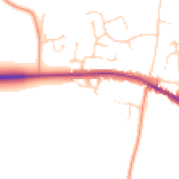
Daytime
07:00 – 23:00
49.0dB
Low
Night-time
23:00 – 07:00
40.4dB
Low55 dB
60 dB
65 dB
70 dB
75 dB
80 dB
Defra Road Noise Strategic Mapping, Round 4Crime Analysis
6 months of data for Colchester
Total Crimes
18
Monthly Avg
3
Recent Trend
Stable
Most Common
Violence & Sexual
Crime by Category
Violence & Sexual10(56%)
Drugs2(11%)
Burglary2(11%)
Other Theft1(6%)
Vehicle Crime1(6%)
Public Order1(6%)
Criminal Damage & Arson1(6%)
Recent Incidents
Drugs
Jan 2026On or near Bramley Close
Other Theft
Nov 2025On or near Church Road
Violence & Sexual
Nov 2025On or near Merlin End
Violence & Sexual
Nov 2025On or near Merlin End
Violence & Sexual
Nov 2025On or near Merlin End
Violence & Sexual
Nov 2025On or near Merlin End
Data from Police UK • Updated monthly
Local Amenities
Schools and transport links nearby
Nearby Schools
4 within 3kmP
Elmstead Primary School
466m
6 mins
P
Broomgrove Infant School
2.7km
32 mins
P
Broomgrove Junior School
2.7km
32 mins
Transport Links
22 within 3kmOatlands
Bus Stop150m
2 mins
Chapel Ln
Bus Stop396m
5 mins
Elmstead Market
Bus Stop789m
10 mins
Blossomwood Farm
Bus Stop904m
11 mins
Beth Chatto Gdns
Bus Stop1.2km
15 mins
Park Farm
Bus Stop1.7km
21 mins
School data from Dept. for Education • Transport data from NaPTAN
Nearby Property Businesses
Local professionals serving this area
Surveyor
Richard Bedford Surveying
Colchester
RICSResidential
Surveyor
Morley Valentin Properties Limited
Colchester
RICS
Surveyor
Morley Riches, Chartered Surveyors
Colchester
RICS
Surveyor
East Block Group Limited
Colchester
RICSResidential
Surveyor
Jon Ablewhite Chartered Surveyor
Colchester
RICSResidential
Surveyor
Lansdowne Warwick
Colchester
RICS
Surveyor
Iain Bain Surveying
Colchester
RICSResidential
Surveyor
Whybrow & Dodds Limited
Colchester
RICSResidential
Map
26 points of interest nearby
Map data from OpenStreetMap • Transport data from NaPTAN • School data from Dept. for Education • Scenic data from Beautifulplaces.ai
Frequently Asked Questions
Common questions about this property