Are you a property professional?Get qualified leads from motivated homeowners.
Get startedDetached
3 The Hollies, West Wellow, Romsey, SO51 6GH
This 113 square metre property in West Wellow, Romsey, Romsey carries an energy performance rating of D, in line with typical UK homes. It is heated by a gas central heating system and is currently listed as owner-occupied. The property last sold for £492,500 in 2021, representing a significant increase from its previous sale.
Property Type
Detached House
Bedrooms
4
Bathrooms
2
Floor Area
113 m²
Council Tax
Band E
Property Features
Built 1983–1990
Private Garden
Rear
Integral Garage
Off-street covered parking
Gas Heating
En-suite Bathroom
Private bathroom attached to bedroom
Utility Room
Separate laundry and storage
Cloakroom
Downstairs WC
Get started
Ready to take the next step? Find the right professionals for your property journey.
Energy Performance
EPC rating and efficiency details
Current Certificate(1 of 2)
May 2021
EPC Rating
A
B
C
D
D66
E
F
G
Main Heating
Gas
Main Fuel
Gas
Hot Water
Good
Windows
Good
CO2 Emissions
4.1 t/year
Tenure
Owner Occupied
Property Improvements
Changes detected from historical EPC data
May 2021from Jul 2010
Windows
AverageGood
Window efficiency improved
Are we missing something? Tell us about home improvements to help adjust your valuation.
Price & History
Transactions and market trends
Estimated value
£522,000
How our AI predicts property prices · Accurate to within 10%
Automated estimate only. For an accurate valuation, consult a surveyor or estate agent.
Transaction history
+364.8%(25y)
£492,500Latest
Aug 2021£105,950
Nov 1996Source: HM Land Registry
Nearby in SO51 6GH
6 The Hollies West Wellow Romsey SO51 6GH
Sept 2021
£375,000
5 The Hollies West Wellow Romsey SO51 6GH
Aug 2018
£313,000
1 The Hollies West Wellow Romsey SO51 6GH
Mar 2007
£310,000
2 The Hollies West Wellow Romsey SO51 6GH
Dec 2006
£316,000
4 The Hollies West Wellow Romsey SO51 6GH
Nov 1996
£75,950
7 The Hollies West Wellow Romsey SO51 6GH
Oct 1996
£75,950
House Price Index
England+1.5%
101.6
Jan 26
UK HPI from HM Land Registry. Baseline: Jan 2015 = 100.
How This Property Compares on The Hollies
See how this property stacks up against others nearby
Not enough similar properties in this postcode to make meaningful comparisons.
Get alerts for SO51 6GH
New sales, price changes, and market updates in this area
About West Wellow, Romsey
This property is located in Wellow, a village and civil parish in Hampshire, England that lies just outside the New Forest and across the main A36 road.
Wellow, Hampshire is a village and civil parish in the Test Valley district of Hampshire, England. The parish sits just outside the New Forest, across the main A36 road which runs from the M27 motorway to Salisbury. The nearest town is Romsey, 4 miles (6.4 km) to the east, and the closest city is Southampton, 9 miles (14 km) to the southeast. According to the 2021 census, the parish had a population of 3,239. The setting offers a rural atmosphere with proximity to larger urban centres and major road links. The village’s location near the New Forest provides access to natural scenery and outdoor activities, while the nearby A36 gives straightforward routes to the M27 motorway and other destinations. Residents can benefit from the village’s community character and the convenience of nearby towns for shopping, services and employment.
Places to visit
Road Noise
Average road noise levels for this postcode
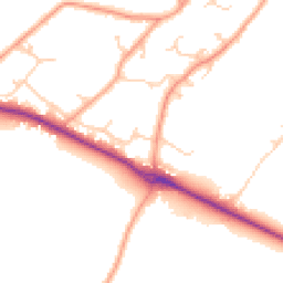
Daytime
07:00 – 23:00
49.1dB
Low
Night-time
23:00 – 07:00
41.0dB
Low55 dB
60 dB
65 dB
70 dB
75 dB
80 dB
Defra Road Noise Strategic Mapping, Round 4Crime Analysis
3 months of data for Romsey
Total Crimes
9
Monthly Avg
3
Recent Trend
Stable
Most Common
Violence & Sexual
Crime by Category
Violence & Sexual7(78%)
Other Theft1(11%)
Public Order1(11%)
Recent Incidents
Violence & Sexual
Oct 2025On or near Dowling Crescent
Violence & Sexual
Oct 2025On or near Parking Area
Violence & Sexual
Oct 2025On or near Parking Area
Violence & Sexual
Oct 2025On or near Dowling Crescent
Other Theft
Oct 2025On or near Butlers Close
Violence & Sexual
Oct 2025On or near Parking Area
Data from Police UK • Updated monthly
Local Amenities
Schools and transport links nearby
Nearby Schools
1 within 3kmP
Wellow Primary School
1.8km
22 mins
Transport Links
18 within 3kmGurnays Mead
Bus Stop60m
1 min
Canada Corner
Bus Stop228m
3 mins
Slab Lane
Bus Stop232m
3 mins
Wheatears Drive
Bus Stop380m
5 mins
Chatmohr
Bus Stop645m
8 mins
War Memorial
Bus Stop833m
10 mins
School data from Dept. for Education • Transport data from NaPTAN
Nearby Property Businesses
Local professionals serving this area
Surveyor
TPS Estates (Management) Ltd
Romsey
RICSResidential
Surveyor
Robin Austin Property Surveyors LLP
Romsey
RICS
Surveyor
Welling Partnership LLP
Romsey
RICSResidential
Surveyor
Trinity Rose - Chartered Surveyors
Romsey
RICS
Surveyor
Warwick Martel
Romsey
RICSResidential
Surveyor
Robert H Davis
Romsey
RICS
Surveyor
The Brindley Partnership Ltd
Romsey
RICSResidential
Surveyor
John C Haxforth
Romsey
RICS
Map
19 points of interest nearby
Map data from OpenStreetMap • Transport data from NaPTAN • School data from Dept. for Education • Scenic data from Beautifulplaces.ai
Frequently Asked Questions
Common questions about this property