Are you a property professional?Get qualified leads from motivated homeowners.
Get startedLong-term Owner
87, Woodmancote, Dursley, GL11 4AG
This property in Woodmancote, Dursley, Dursley. Records show the property last changed hands for £170,000 back in 2005.
Property Type
Property
Bedrooms
—
Floor Area
— m²
Council Tax
Band D
Get started
Ready to take the next step? Find the right professionals for your property journey.
Energy Performance
EPC rating and efficiency details
A
B
C
D
E
F
G
No EPC on record
This property doesn't have an Energy Performance Certificate yet. An EPC helps us give a more accurate valuation and is required to sell or let.
Price & History
Transactions and market trends
Transaction history
£170,000Latest
Oct 2005Source: HM Land Registry
Nearby in GL11 4AG
67 Woodmancote Dursley GL11 4AG
Oct 2024
£145,000
71 Woodmancote Dursley GL11 4AG
May 2024
£165,000
85 Woodmancote Dursley GL11 4AG
Mar 2023
£335,000
79c Woodmancote Dursley GL11 4AG
Jan 2023
£260,000
79b Woodmancote Dursley GL11 4AG
Sept 2022
£322,250
65 Woodmancote Dursley GL11 4AG
Aug 2022
£240,000
1 / 3
House Price Index
England+1.5%
101.6
Jan 26
UK HPI from HM Land Registry. Baseline: Jan 2015 = 100.
How This Property Compares
See how this property stacks up against others nearby
Not enough similar properties in this postcode to make meaningful comparisons.
Get alerts for GL11 4AG
New sales, price changes, and market updates in this area
About Woodmancote, Dursley
This property is located in Woodmancote, a village in Stroud District, Gloucestershire, England, close to the larger town of Dursley.
Woodmancote, Dursley is a small village in Stroud District, Gloucestershire, England. The locality is described as a village near Dursley, situated within Gloucestershire. The summary notes that Woodmancote is a small village near Dursley in Gloucestershire, England. The description confirms it is a village in Stroud District, Gloucestershire, England.
Places to visit
Road Noise
Average road noise levels for this postcode
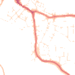
Daytime
07:00 – 23:00
46.6dB
Low
Night-time
23:00 – 07:00
38.1dB
Low55 dB
60 dB
65 dB
70 dB
75 dB
80 dB
Defra Road Noise Strategic Mapping, Round 4Crime Analysis
8 months of data for Dursley
Total Crimes
13
Monthly Avg
2
Recent Trend
Stable
Most Common
Violence & Sexual
Crime by Category
Violence & Sexual9(69%)
Other Crime1(8%)
Vehicle Crime1(8%)
Criminal Damage & Arson1(8%)
Public Order1(8%)
Recent Incidents
Violence & Sexual
Nov 2025On or near The Ham
Other Crime
Nov 2025On or near Orchard Leaze
Vehicle Crime
Nov 2025On or near Orchard Leaze
Violence & Sexual
Sept 2025On or near Fourth Avenue
Violence & Sexual
Sept 2025On or near Box Road Avenue
Violence & Sexual
Jul 2025On or near Fourth Avenue
Data from Police UK • Updated monthly
Local Amenities
Schools and transport links nearby
Nearby Schools
5 within 3kmP
Dursley Church of England Primary Academy
451m
5 mins
P
Cam Everlands Primary School
2.1km
26 mins
P
Cam Hopton Church of England Primary School
2.3km
27 mins
S
Rednock School
1.2km
15 mins
Transport Links
30 within 3kmCambridge House
Bus Stop150m
2 mins
Vizard Close
Bus Stop196m
2 mins
Somerset Avenue
Bus Stop216m
3 mins
Nunnery Lane
Bus Stop248m
3 mins
Rangers Avenue
Bus Stop257m
3 mins
May Lane Bus Station
Bus Station746m
9 mins
School data from Dept. for Education • Transport data from NaPTAN
Nearby Property Businesses
Local professionals serving this area
Map
35 points of interest nearby
Map data from OpenStreetMap • Transport data from NaPTAN • School data from Dept. for Education • Scenic data from Beautifulplaces.ai
Frequently Asked Questions
Common questions about this property