Are you a property professional?Get qualified leads from motivated homeowners.
Get startedEdwardianHigh Ceilings
2 Ravenscroft Road, Prenton, CH43 4XY
This 133 square metre property in Prenton carries an energy performance rating of D, in line with typical UK homes. It is heated by a gas central heating system and is currently listed as owner-occupied.
Property Type
Semi-Detached House
Bedrooms
4
Floor Area
133 m²
Council Tax
Band B
Property Features
Built 1900–1929
Get started
Ready to take the next step? Find the right professionals for your property journey.
Energy Performance
EPC rating and efficiency details
EPC Rating
A
B
C
D
D66
E
F
G
Main Heating
Gas
Main Fuel
Gas
Hot Water
Good
Windows
Average
CO2 Emissions
5.1 t/year
Tenure
Owner Occupied
Price & History
Transactions and market trends
Estimated value
£229,000
How our AI predicts property prices · Accurate to within 10%
Automated estimate only. For an accurate valuation, consult a surveyor or estate agent.
Transaction history
No sales history found
Nearby in CH43 4XY
16 Ravenscroft Road Prenton CH43 4XY
Dec 2024
£157,000
9 Ravenscroft Road Prenton CH43 4XY
Sept 2023
£153,000
14 Ravenscroft Road Prenton CH43 4XY
Sept 2022
£250,000
10 Ravenscroft Road Prenton CH43 4XY
Jun 2014
£90,000
13 Ravenscroft Road Prenton CH43 4XY
Mar 2013
£97,500
Flat 1 15 Ravenscroft Road Prenton CH43 4XY
May 2008
£84,000
1 / 3
House Price Index
England+1.5%
101.6
Jan 26
UK HPI from HM Land Registry. Baseline: Jan 2015 = 100.
How This Property Compares on Ravenscroft Road
See how this property stacks up against others nearby
Comparing to 10 other houses on this street
EPC Rating
Government energy efficiency score (1–100)
66 (D)/59 (D) avg
Less efficientMore efficient
More efficient than 75% of similar properties
Floor Area
Total internal floor space
133 m²/143 m² avg
SmallerLarger
Larger than only 20% of similar properties
CO₂ Emissions
Annual carbon output from heating, hot water & lighting
5.1 t/year/6.5 t/year avg
Higher emissionsLower emissions
Lower emissions than 80% of similar properties
Habitable Rooms
Living spaces like bedrooms & living rooms
6 rooms/7 rooms avg
FewerMore
More rooms than only 20% of similar properties
Comparisons are based on the most recent EPC data for each property in this postcode. Only similar property types (houses) are compared.
Get alerts for CH43 4XY
New sales, price changes, and market updates in this area
Places to visit
Road Noise
Average road noise levels for this postcode
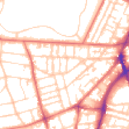
Daytime
07:00 – 23:00
53.4dB
Low
Night-time
23:00 – 07:00
41.4dB
Low55 dB
60 dB
65 dB
70 dB
75 dB
80 dB
Defra Road Noise Strategic Mapping, Round 4Crime Analysis
7 months of data for Prenton
Total Crimes
17
Monthly Avg
2
Recent Trend
Stable
Most Common
Violence & Sexual
Crime by Category
Violence & Sexual11(65%)
Burglary2(12%)
Public Order2(12%)
Criminal Damage & Arson2(12%)
Recent Incidents
Burglary
Dec 2025On or near Fender Lane
Violence & Sexual
Nov 2025On or near Stoneridge Court
Violence & Sexual
Nov 2025On or near Stoneridge Court
Violence & Sexual
Nov 2025On or near Wexford Road
Violence & Sexual
Nov 2025On or near Observatory Road
Violence & Sexual
Nov 2025On or near Ledbury Close
Data from Police UK • Updated monthly
Local Amenities
Schools and transport links nearby
Nearby Schools
34 within 3kmP
Birkenhead Christ Church CofE Primary School
520m
6 mins
P
St Werburgh's Catholic Primary School
561m
7 mins
P
Woodlands Primary School
777m
9 mins
S
Birkenhead Park School
398m
5 mins
S
St Anselm's College
748m
9 mins
S
Birkenhead High School Academy
826m
10 mins
Transport Links
30 within 3kmGrange Road West
Bus Stop185m
2 mins
Grange Road West
Bus Stop199m
2 mins
Francis Avenue
Bus Stop224m
3 mins
St Helens Close
Bus Stop272m
3 mins
Cole Street
Bus Stop274m
3 mins
Paterson Street
Bus Stop274m
3 mins
School data from Dept. for Education • Transport data from NaPTAN
Nearby Property Businesses
Local professionals serving this area
Map
64 points of interest nearby
Map data from OpenStreetMap • Transport data from NaPTAN • School data from Dept. for Education • Scenic data from Beautifulplaces.ai
Frequently Asked Questions
Common questions about this property